
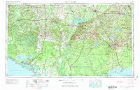
~ Tallahassee FL topo map, 1:250000 scale, 1 X 2 Degree, Historical, 1954, updated 1973
Tallahassee, Florida, USGS topographic map dated 1954.
Includes geographic coordinates (latitude and longitude). This topographic map is suitable for hiking, camping, and exploring, or framing it as a wall map.
Printed on-demand using high resolution imagery, on heavy weight and acid free paper, or alternatively on a variety of synthetic materials.
Topos available on paper, Waterproof, Poly, or Tyvek. Usually shipping rolled, unless combined with other folded maps in one order.
- Product Number: USGS-5621790
- Free digital map download (high-resolution, GeoPDF): Tallahassee, Florida (file size: 20 MB)
- Map Size: please refer to the dimensions of the GeoPDF map above
- Weight (paper map): ca. 55 grams
- Map Type: POD USGS Topographic Map
- Map Series: HTMC
- Map Verison: Historical
- Cell ID: 69044
- Scan ID: 348776
- Imprint Year: 1973
- Woodland Tint: Yes
- Edit Year: 1966
- Field Check Year: 1954
- Datum: Unstated
- Map Projection: Transverse Mercator
- Map published by United States Geological Survey
- Map published by United States Army Corps of Engineers
- Map published by United States Army
- Map Language: English
- Scanner Resolution: 600 dpi
- Map Cell Name: Tallahassee
- Grid size: 1 X 2 Degree
- Date on map: 1954
- Map Scale: 1:250000
- Geographical region: Florida, United States
Neighboring Maps:
All neighboring USGS topo maps are available for sale online at a variety of scales.
Spatial coverage:
Topo map Tallahassee, Florida, covers the geographical area associated the following places:
- Cerrogordo - Ivan - Hiamonee (historical) - Branchville - Fawn Ford - Shady Rest - Cottondale - Durham (historical) - Graceville - Bid-A-Wee - Gilberts Mill - Bethel - Oakdale - Osochi (historical) - Wakulla Springs - Underwood Crossing - Saint Andrew - Steele City - Lynn - Greenhead - Henderson Mill - Butler (historical) - Douglass Crossroads - Parker Courthouse - Topkegaiga (historical) - Smith Crossroads - Broad Branch - Concord - Waddells Mill - Cairo - Pine Park - Darsey - Gulf Lagoon Beach - Southport - Bethlehem - Rock Creek - Holmes Valley - Gardner - Bloxham - Shell Island - Cody - Betts - Whigham - Cedar Grove - Laingkat - Woodville - Midway - Rambo - Blountstown - Quincy - Henrietta - Chipley - Plum Orchard - Hoover Mill - River Junction - Pretty Bayou - Conners Ford - Ochlocknee - Lake Grove - Kinard - Ponce de Leon - Lovedale - Greensboro - Hulaw - Wetumpka - Wewahitchka - Jinks - Bridle Path Acres - Farmdale - Brock Crossroad - Lake Jackson - Esto - Bascom - Hobbs Crossroads - Bethel - Jackson Bluff - Douglas City - Millville - Redbay - Arrant Settlement - Panacea - Brownlee - Two Egg - Selman - San Carlos Chacatos (historical) - Roddenberry - Chaires - Baum - Paradise Acres - Lower Grand Lagoon - Ashmore - Simsville - Mosquito Landing - Spring Creek - Mallory Heights - Tamathli (historical) - Lowry - Richter Crossroads - Ards Crossroads - Caryville
- Map Area ID: AREA3130-86-84
- Northwest corner Lat/Long code: USGSNW31-86
- Northeast corner Lat/Long code: USGSNE31-84
- Southwest corner Lat/Long code: USGSSW30-86
- Southeast corner Lat/Long code: USGSSE30-84
- Northern map edge Latitude: 31
- Southern map edge Latitude: 30
- Western map edge Longitude: -86
- Eastern map edge Longitude: -84


