
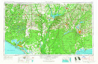
~ Tallahassee FL topo map, 1:250000 scale, 1 X 2 Degree, Historical, 1954, updated 1967
Tallahassee, Florida, USGS topographic map dated 1954.
Includes geographic coordinates (latitude and longitude). This topographic map is suitable for hiking, camping, and exploring, or framing it as a wall map.
Printed on-demand using high resolution imagery, on heavy weight and acid free paper, or alternatively on a variety of synthetic materials.
Topos available on paper, Waterproof, Poly, or Tyvek. Usually shipping rolled, unless combined with other folded maps in one order.
- Product Number: USGS-5621788
- Free digital map download (high-resolution, GeoPDF): Tallahassee, Florida (file size: 19 MB)
- Map Size: please refer to the dimensions of the GeoPDF map above
- Weight (paper map): ca. 55 grams
- Map Type: POD USGS Topographic Map
- Map Series: HTMC
- Map Verison: Historical
- Cell ID: 69044
- Scan ID: 348775
- Imprint Year: 1967
- Woodland Tint: Yes
- Edit Year: 1966
- Field Check Year: 1954
- Datum: Unstated
- Map Projection: Transverse Mercator
- Map published by United States Army Corps of Engineers
- Map published by United States Army
- Map Language: English
- Scanner Resolution: 600 dpi
- Map Cell Name: Tallahassee
- Grid size: 1 X 2 Degree
- Date on map: 1954
- Map Scale: 1:250000
- Geographical region: Florida, United States
Neighboring Maps:
All neighboring USGS topo maps are available for sale online at a variety of scales.
Spatial coverage:
Topo map Tallahassee, Florida, covers the geographical area associated the following places:
- Telogia - San Carlos Chacatos (historical) - Ards Crossroads - Wadesboro - Recovery - Durham (historical) - Crystal Lake - Juniper - Moncrief - Saunders - Havana - Blountstown - Brownlee - Hulaw - Chattahoochee - Jinks - Meridian - Welika (historical) - Limestone - Lynn Haven - Noma - Majette - Wakulla Beach - Boydville - Steele City - Willis - Florence - Harbinwood Estates - Cohowfoochee (historical) - Vicksburg - San Marcos (historical) - Reynoldsville - Sink Creek - Amsterdam - Choconickla (historical) - Altha - Alford - Ellis Church - Eleanor - Woodville - Fountain - Star - Buena Vista - Izagora - Gunn Landing - Cox - Bayhead - Wethocouchy (historical) - Sawdust - Tully - Pine Park - Gritney - Mosquito Landing - Fisher Corner - Wynnlum - Delwood Beach - Topkegaiga (historical) - Youngstown - Coosada Old Town (historical) - Smith Crossroads - Branchville - Sharpstown - Esto - Malone - Littman - White Springs - Westville - Scotland - Hardin Heights - Pretty Bayou - Wewahitchka - Akridge - Alliance - Oakdale - Bellwood Estates - Lakeside - Hosford - Bahama Beach - Cook - Newport - Collins Mill - Escambia (historical) - Baum - Wausau - Four Points - Bay Harbor - Blocker - Homestead Ridge - Knox Hill - Darsey - Sunnyside - Resota Beach - Sylvania - Campbellton - Kinard - Douglas City - Springfield - Bahoma - Lewis - Jacobs
- Map Area ID: AREA3130-86-84
- Northwest corner Lat/Long code: USGSNW31-86
- Northeast corner Lat/Long code: USGSNE31-84
- Southwest corner Lat/Long code: USGSSW30-86
- Southeast corner Lat/Long code: USGSSE30-84
- Northern map edge Latitude: 31
- Southern map edge Latitude: 30
- Western map edge Longitude: -86
- Eastern map edge Longitude: -84


