
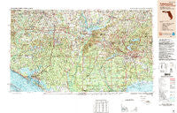
~ Tallahassee FL topo map, 1:250000 scale, 1 X 2 Degree, Historical, 1988, updated 1988
Tallahassee, Florida, USGS topographic map dated 1988.
Includes geographic coordinates (latitude and longitude). This topographic map is suitable for hiking, camping, and exploring, or framing it as a wall map.
Printed on-demand using high resolution imagery, on heavy weight and acid free paper, or alternatively on a variety of synthetic materials.
Topos available on paper, Waterproof, Poly, or Tyvek. Usually shipping rolled, unless combined with other folded maps in one order.
- Product Number: USGS-5621784
- Free digital map download (high-resolution, GeoPDF): Tallahassee, Florida (file size: 26 MB)
- Map Size: please refer to the dimensions of the GeoPDF map above
- Weight (paper map): ca. 55 grams
- Map Type: POD USGS Topographic Map
- Map Series: HTMC
- Map Verison: Historical
- Cell ID: 69044
- Scan ID: 348773
- Imprint Year: 1988
- Woodland Tint: Yes
- Visual Version Number: 1
- Aerial Photo Year: 1985
- Edit Year: 1988
- Datum: NAD27
- Map Projection: Universal Transverse Mercator
- Map published by United States Geological Survey
- Map Language: English
- Scanner Resolution: 600 dpi
- Map Cell Name: Tallahassee
- Grid size: 1 X 2 Degree
- Date on map: 1988
- Map Scale: 1:250000
- Geographical region: Florida, United States
Neighboring Maps:
All neighboring USGS topo maps are available for sale online at a variety of scales.
Spatial coverage:
Topo map Tallahassee, Florida, covers the geographical area associated the following places:
- Waddells Mill - Wakulla Springs - Hardaway - Live Oak Island - Wilma - Upper Grand Lagoon - Morgan Place - Highnote - Sawdust - Rich Bay - Youngstown - Gulf Lagoon Beach - Panama City Beach - Betts - Bradford - Norum - Perkins - Wetappo - Early - Ochlocknee - Jackson Bluff - Littman - Izagora - Holland - Oak Knoll Estates - Richter Crossroads - Iola - Bahama Beach - Buckhorn - Long Point - Cohowfoochee (historical) - Saint Peter - Reynoldsville - Chipola Terrace - Rose - Calvary - Majette - Hulaw - Beachton - Two Egg - Simsville - Reno - Eufala (historical) - Inwood - Vereen - Riverturn - Plum Orchard - Gardner - Laird - Osochi (historical) - Marysville - Poplar Head - Pittman - Haynes - Wetumpka - Resota Beach - Pine Park - Escambia (historical) - Delwood Beach - Corey - Baker - Dirego Park - Long Branch - Santa Clara - Vilas - Grantham - Mount Pleasant - Eleanor - Bid-A-Wee - Pebble Hill - Brinson - New Hope - Cyrene - Port Leon - Selman - Prosperity - Lela - Grand Ridge - Gaskins Still - Parker - Lower Grand Lagoon - Abe Springs - Sneads - Dawesville - Shell Island - Tama (historical) - Providence - Westville - Ellaville - Skipper - Steele City - Cove - Helen - Cody - Hyde Park - Mount Pleasant - Homestead Ridge - Limestone - Cottondale - Saint Andrew
- Map Area ID: AREA3130-86-84
- Northwest corner Lat/Long code: USGSNW31-86
- Northeast corner Lat/Long code: USGSNE31-84
- Southwest corner Lat/Long code: USGSSW30-86
- Southeast corner Lat/Long code: USGSSE30-84
- Northern map edge Latitude: 31
- Southern map edge Latitude: 30
- Western map edge Longitude: -86
- Eastern map edge Longitude: -84


