
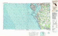
~ St Petersburg FL topo map, 1:250000 scale, 1 X 2 Degree, Historical, 1988, updated 1988
St Petersburg, Florida, USGS topographic map dated 1988.
Includes geographic coordinates (latitude and longitude). This topographic map is suitable for hiking, camping, and exploring, or framing it as a wall map.
Printed on-demand using high resolution imagery, on heavy weight and acid free paper, or alternatively on a variety of synthetic materials.
Topos available on paper, Waterproof, Poly, or Tyvek. Usually shipping rolled, unless combined with other folded maps in one order.
- Product Number: USGS-5621780
- Free digital map download (high-resolution, GeoPDF): St Petersburg, Florida (file size: 29 MB)
- Map Size: please refer to the dimensions of the GeoPDF map above
- Weight (paper map): ca. 55 grams
- Map Type: POD USGS Topographic Map
- Map Series: HTMC
- Map Verison: Historical
- Cell ID: 69007
- Scan ID: 348676
- Imprint Year: 1988
- Woodland Tint: Yes
- Aerial Photo Year: 1984
- Edit Year: 1988
- Datum: NAD27
- Map Projection: Universal Transverse Mercator
- Map published by United States Geological Survey
- Map Language: English
- Scanner Resolution: 600 dpi
- Map Cell Name: Saint Petersburg
- Grid size: 1 X 2 Degree
- Date on map: 1988
- Map Scale: 1:250000
- Geographical region: Florida, United States
Neighboring Maps:
All neighboring USGS topo maps are available for sale online at a variety of scales.
Spatial coverage:
Topo map St Petersburg, Florida, covers the geographical area associated the following places:
- Azalea Gardens - Cashin Oaks - Lake Shore Ranch - Pelican Point - Berry Landing - Durant Trails - Redington Beach - Villa Sonoma at International Plaza - Indian Shores - Arrawana Park - Souders - Sunrise Manor - Busy Bee Haven Mobile Home Park - Lavity - South Bay Lakes - Symmes Grove - Tatum - Calusa Bay - Eleanor Villas - Joannas Reserve - Nebraska Heights South - Verdier Park - Martin - Dorothy Park - Belvedere Acres - Baywood - Boyette Springs - Oscawana - North Shore - East View - South County Estates - Downing - Alameda - Virginia Estates - Waterbury - Sunrise - Country Woods Estates - Lukes - Belmont Heights - Rolling Acres - Delgado - Shady Oaks - Mount Carmel - Kingsway Downs - Boyette - Anita - Michigan Heights - Westlake - Trapnell East - Horizon Place - Jules Verne Park - Sanctuary Estates - Williams Crossing - Camden Woods - Estuary - Parkside Village - Simmons Acres - Woodlawn Park - Half Way Place - Royal Oaks - Armijo Acres - Southgate - White Estates - Raven Oaks - Rock - Fishers - Fullers Earth - Cowart Oaks - Walden Woods - Beverly Park - Oakwood Ravine - Hankins Virginia Heights - Shawnee Hills - Rivershores - Manavista - Marphil Manor - Caloosa Country Club Estates - Clarice Place - Hilton - Hopewell Gardens - Fields Park Place - Burlington Woods - Vamo - Parrish Home - Florida Place - Ranch Road Groves - Mango Terrace - Taylor Heights - River Oaks - Pearson Estates - Belvedere Place - Timber Creek - Bayside West - Progress Village - Oakridge - Ravenwood - Park Place of East Tampa - Interbay - Welikit Retreat - Venice
- Map Area ID: AREA2827-84-82
- Northwest corner Lat/Long code: USGSNW28-84
- Northeast corner Lat/Long code: USGSNE28-82
- Southwest corner Lat/Long code: USGSSW27-84
- Southeast corner Lat/Long code: USGSSE27-82
- Northern map edge Latitude: 28
- Southern map edge Latitude: 27
- Western map edge Longitude: -84
- Eastern map edge Longitude: -82


