
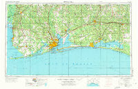
~ Pensacola FL topo map, 1:250000 scale, 1 X 2 Degree, Historical, 1957, updated 1973
Pensacola, Florida, USGS topographic map dated 1957.
Includes geographic coordinates (latitude and longitude). This topographic map is suitable for hiking, camping, and exploring, or framing it as a wall map.
Printed on-demand using high resolution imagery, on heavy weight and acid free paper, or alternatively on a variety of synthetic materials.
Topos available on paper, Waterproof, Poly, or Tyvek. Usually shipping rolled, unless combined with other folded maps in one order.
- Product Number: USGS-5621768
- Free digital map download (high-resolution, GeoPDF): Pensacola, Florida (file size: 21 MB)
- Map Size: please refer to the dimensions of the GeoPDF map above
- Weight (paper map): ca. 55 grams
- Map Type: POD USGS Topographic Map
- Map Series: HTMC
- Map Verison: Historical
- Cell ID: 72242
- Scan ID: 348064
- Imprint Year: 1973
- Woodland Tint: Yes
- Aerial Photo Year: 1955
- Edit Year: 1970
- Field Check Year: 1957
- Datum: Unstated
- Map Projection: Transverse Mercator
- Map published by: Military, Other
- Map Language: English
- Scanner Resolution: 600 dpi
- Map Cell Name: Pensacola
- Grid size: 1 X 2 Degree
- Date on map: 1957
- Map Scale: 1:250000
- Geographical region: Florida, United States
Neighboring Maps:
All neighboring USGS topo maps are available for sale online at a variety of scales.
Spatial coverage:
Topo map Pensacola, Florida, covers the geographical area associated the following places:
- East Milton - Pine Haven - Pensacola Beach - Land Harbor Mobile Home Park - Oak Grove - Nubbin Ridge - Blue Mountain Beach - Simmons Crossing - Rosinton - Indian Ford - Dogwood Park Mobile Home Village and Recreational Vehicle Park - Cannon Town - Beaver Creek - Country Living Mobile Home Park - Longwood - Murray's Mobile Home Park - Santa Rosa Beach - Dune Allen Beach - Gateswood - Jay - Beech Camper and Mobile Home Park - Watercolor - Hurricane - Yelling Settlement - Gordon - Bay Minette - Oak - Montrose - Summerdale - Rosemary Beach - Cantonment - Center Ridge - New Harmony - Paxton - Destin - Gaskin - Leonia - De Funiak Springs - Ramsey's Mobile Home Park - Dead Lake Mobile Home Park - Seascape - Palm Park Mobile Home Park - Holley - Grosh - Quinavista - Country Living Mobile Home Park - Clear Springs - Pelican Mobile Home Park - Magnolia Beach - Brickton - Killingsworth Crossroads - Darlington - Milligan - Four Mile Village - Parkerville - Pineville - Broxson - Choctaw Beach - Muscogee - Fidelis - Harper - Floridale - Orchards Mobile Home Park - Pecan Park Mobile Home Park - Galliver - Gandyville - Houstonville - Cypress Acres Mobile Home Park - Harp - Eglin Village - Whitfield - Chanticleer - Muddy Ford - Mount Carmel - Ferry Pass - Crestview - Country Place Mobile Home Park - Fluffy Landing - Dickman Mobile Home Park - Laurel Hill - La Grange Point - Stockton - Bogia - Wolf Bay Park Mobile Home Park - Park City - Gulf Beach Heights - Jackson Oak - Deerland - Jacks Trailer Court - East Park Plaza Mobile Home Park - Hughes Mobile Home Park - Happy Valley - Eastern Shore Mobile Home Village - Satsuma Heights - Forest Highlands - Liberty - Rock Creek - Miramar Beach - Freeport - Blue Grass Recreational Vehicle Park
- Map Area ID: AREA3130-88-86
- Northwest corner Lat/Long code: USGSNW31-88
- Northeast corner Lat/Long code: USGSNE31-86
- Southwest corner Lat/Long code: USGSSW30-88
- Southeast corner Lat/Long code: USGSSE30-86
- Northern map edge Latitude: 31
- Southern map edge Latitude: 30
- Western map edge Longitude: -88
- Eastern map edge Longitude: -86


