
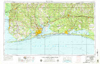
~ Pensacola FL topo map, 1:250000 scale, 1 X 2 Degree, Historical, 1957, updated 1979
Pensacola, Florida, USGS topographic map dated 1957.
Includes geographic coordinates (latitude and longitude). This topographic map is suitable for hiking, camping, and exploring, or framing it as a wall map.
Printed on-demand using high resolution imagery, on heavy weight and acid free paper, or alternatively on a variety of synthetic materials.
Topos available on paper, Waterproof, Poly, or Tyvek. Usually shipping rolled, unless combined with other folded maps in one order.
- Product Number: USGS-5621766
- Free digital map download (high-resolution, GeoPDF): Pensacola, Florida (file size: 20 MB)
- Map Size: please refer to the dimensions of the GeoPDF map above
- Weight (paper map): ca. 55 grams
- Map Type: POD USGS Topographic Map
- Map Series: HTMC
- Map Verison: Historical
- Cell ID: 72242
- Scan ID: 348063
- Imprint Year: 1979
- Woodland Tint: Yes
- Aerial Photo Year: 1955
- Edit Year: 1970
- Field Check Year: 1957
- Datum: Unstated
- Map Projection: Transverse Mercator
- Map published by: Military, Other
- Map Language: English
- Scanner Resolution: 600 dpi
- Map Cell Name: Pensacola
- Grid size: 1 X 2 Degree
- Date on map: 1957
- Map Scale: 1:250000
- Geographical region: Florida, United States
Neighboring Maps:
All neighboring USGS topo maps are available for sale online at a variety of scales.
Spatial coverage:
Topo map Pensacola, Florida, covers the geographical area associated the following places:
- Rosinton - Old Bratt Road Estates - Riverview - Galliver - Phillipsville - South Flomaton - C'est Lavie Mobile Home Park - Choctaw Beach - Fort McDermott - Olive - Daphne - Warrington - Broxson - Century - Holt - Pleasant Grove - Cobbtown - Jay - Clear Springs - Seagrove Beach - Gonzalez - Piney Grove - Barnwell - Point Clear - Lillian - Darlington - Steele Church - Spanish Fort - Woodlawn Beach - Sand Cut - Summerdale - Dickerson City - Walnut Hill - Dogwood Park Mobile Home Village and Recreational Vehicle Park - Eastwood - Holley - Pina's Mobile Home Park - Dana Point - Dead Lake Mobile Home Park - Whitfield - Country Place Mobile Home Park - Sanders Beach - Nubbin Ridge - Center Ridge - Stockton - Seminole - Dickman Mobile Home Park - Pine Bluff - Foley Recreational Vehicle Park - Harris - Beach Highlands - Union - Cosson Mill - Chanticleer - Bluff Springs - Sandestin - Muddy Ford - Loyola Villa - Villa Tasso - Ocean City - Gulf Breeze - Parkway Mobile Home Park - Mallard Point Trailer Court - Miramar Beach - Pulliam Village Mobile Home Park - Bayside - Autumn Park Mobile Home Park - Old Charles Mobile Home Park - Eastern Shore Mobile Home Village - Pleasant Grove - Big Hammock - Old Bay View - Orange Beach - Sellersville - Styx River Estates - Paradise Beach - Oak - Paxton - Pelican Mobile Home Park - Floridale - Tenile - Bogia - Windsor Place Mobile Home Park - Lakewood - Daphne Mobile Home Park - Whispering Pines Mobile Home Park - Whispering Winds Mobile Home Park - Belforest - Niceville - Silverhill Mobile Home Park - Myrtle Grove - Gulf Shores - Perdido Beach - Portland - Brent - Park City - Fidelis - Bay Minette - Oyster Lodge - Belandville
- Map Area ID: AREA3130-88-86
- Northwest corner Lat/Long code: USGSNW31-88
- Northeast corner Lat/Long code: USGSNE31-86
- Southwest corner Lat/Long code: USGSSW30-88
- Southeast corner Lat/Long code: USGSSE30-86
- Northern map edge Latitude: 31
- Southern map edge Latitude: 30
- Western map edge Longitude: -88
- Eastern map edge Longitude: -86


