
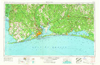
~ Pensacola FL topo map, 1:250000 scale, 1 X 2 Degree, Historical, 1957, updated 1967
Pensacola, Florida, USGS topographic map dated 1957.
Includes geographic coordinates (latitude and longitude). This topographic map is suitable for hiking, camping, and exploring, or framing it as a wall map.
Printed on-demand using high resolution imagery, on heavy weight and acid free paper, or alternatively on a variety of synthetic materials.
Topos available on paper, Waterproof, Poly, or Tyvek. Usually shipping rolled, unless combined with other folded maps in one order.
- Product Number: USGS-5621764
- Free digital map download (high-resolution, GeoPDF): Pensacola, Florida (file size: 16 MB)
- Map Size: please refer to the dimensions of the GeoPDF map above
- Weight (paper map): ca. 55 grams
- Map Type: POD USGS Topographic Map
- Map Series: HTMC
- Map Verison: Historical
- Cell ID: 72242
- Scan ID: 348062
- Imprint Year: 1967
- Woodland Tint: Yes
- Edit Year: 1966
- Field Check Year: 1957
- Datum: Unstated
- Map Projection: Transverse Mercator
- Map published by United States Army Corps of Engineers
- Map published by United States Army
- Map published by: Military, Other
- Map Language: English
- Scanner Resolution: 600 dpi
- Map Cell Name: Pensacola
- Grid size: 1 X 2 Degree
- Date on map: 1957
- Map Scale: 1:250000
- Geographical region: Florida, United States
Neighboring Maps:
All neighboring USGS topo maps are available for sale online at a variety of scales.
Spatial coverage:
Topo map Pensacola, Florida, covers the geographical area associated the following places:
- Jay - Pensacola Beach - Gordon - Gonzalez - Barth - Pine Grove - Koerber - Glendale - Yelling Settlement - Grayton Beach - Parkway Mobile Home Park - Cinco Bayou - Perdido Key - Sand Cut - Elijah Shoots Mobile Home Park - De Funiak Springs - Pina's Mobile Home Park - Muscogee - Country Living Mobile Home Park - Helens Mobile Home Park and Recreational Vehicle Park - Broxson - Malbis - Lillie's Mobile Home Park - Laurel Hill - Destin - Gulf Beach Heights - Orchards Mobile Home Park - Cosson Mill - Seminole - Carpenter - Oak Grove - Stockton - Paradise Beach - Seacrest - Perdido Beach - Cottage Hill - La Grange Point - Sherman Grove - Leonia - Mount Carmel - River Park - Bay View - Bay Springs - Avondale - Bagdad - Oak - Wallace - Gulf Highlands - Country Village Mobile Home Park - Park City - Holley - Cerny Heights - Choctaw Bay Estates - Quinavista - Carney - Seaside - Jackson Oak - Wright - Freeport - Point Washington - Harris - Milton - Sanders Beach - Palmetto Beach - Dana Point - Brickton - Foley - Lake Lorraine - Eucheeanna - Villa Sabine - Hughes Mobile Home Park - Bromley - Watercolor - Miramar Beach - Oyster Bay - Floridale - Barnwell - Century - Fidelis - Dead Lake Mobile Home Park - Clear Springs - Molino Crossroads - Bayside - Gulf Breeze - Bunker - Longwood - Cedarbreeze Mobile Home Park - Tenile - Rock Creek - Romar Beach - Galt City - Peaden - Munson - Murray's Mobile Home Park - Enon - Summerdale - Oyster Lodge - Walnut Hill - Pleasant Grove - Live Oak Mobile Home Park
- Map Area ID: AREA3130-88-86
- Northwest corner Lat/Long code: USGSNW31-88
- Northeast corner Lat/Long code: USGSNE31-86
- Southwest corner Lat/Long code: USGSSW30-88
- Southeast corner Lat/Long code: USGSSE30-86
- Northern map edge Latitude: 31
- Southern map edge Latitude: 30
- Western map edge Longitude: -88
- Eastern map edge Longitude: -86


