
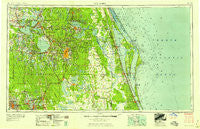
~ Orlando FL topo map, 1:250000 scale, 1 X 2 Degree, Historical, 1958, updated 1958
Orlando, Florida, USGS topographic map dated 1958.
Includes geographic coordinates (latitude and longitude). This topographic map is suitable for hiking, camping, and exploring, or framing it as a wall map.
Printed on-demand using high resolution imagery, on heavy weight and acid free paper, or alternatively on a variety of synthetic materials.
Topos available on paper, Waterproof, Poly, or Tyvek. Usually shipping rolled, unless combined with other folded maps in one order.
- Product Number: USGS-5621754
- Free digital map download (high-resolution, GeoPDF): Orlando, Florida (file size: 16 MB)
- Map Size: please refer to the dimensions of the GeoPDF map above
- Weight (paper map): ca. 55 grams
- Map Type: POD USGS Topographic Map
- Map Series: HTMC
- Map Verison: Historical
- Cell ID: 68950
- Scan ID: 347860
- Imprint Year: 1958
- Woodland Tint: Yes
- Field Check Year: 1955
- Datum: Unstated
- Map Projection: Transverse Mercator
- Map published by United States Army Corps of Engineers
- Map published by United States Army
- Map Language: English
- Scanner Resolution: 600 dpi
- Map Cell Name: Orlando
- Grid size: 1 X 2 Degree
- Date on map: 1958
- Map Scale: 1:250000
- Geographical region: Florida, United States
Neighboring Maps:
All neighboring USGS topo maps are available for sale online at a variety of scales.
Spatial coverage:
Topo map Orlando, Florida, covers the geographical area associated the following places:
- Suttons Mobile Home Park - Fox Town - Carters Corner - Davenport - Twin Oaks Park Mobile Home Park - Greenbriar - Flora Heights - Riviera Mobile Home Park - Happy Acres Mobile Home Park - Pyramid Park Mobile Home Park - Audubon - Alafaya Woods - Wagner - Tiki Village Mobile Home Park - Hollandale Mobile Home Park - Bamboo - Lake Buena Vista - Snow Hill - Fort Mason - Oak Tree Park - Lake Ashby Shores - Sanlando Springs - Weirsdale - Bonny Shores Mobile Home Park - Jones Landing - Southgate Mobile Homes - Allenhurst - Carriage Cove Mobile Home Park - Cassadaga - May Manor Mobile Home Park - Palm Bay Estates Mobile Home Park - Bassville Park - Twin Oaks Mobile Home Park - Oak Ridge - Osceola - Canaveral (historical) - Lakeside Village Mobile Home Park - Cocoa Beach Trailer Park - L and M Mobile Court - Lockhart Mobile Home Park - Pine Grove Mobile Home Park - Withla - Country Club Manor - Johnson Mobile Home Park - Town and Country Mobile Home Park - Hillside Mobile Home Park - Winter Springs - Camino Park Mobile Home Park - Orange Trailer Manor Mobile Home Park - Indialantic - Country Village Mobile Home Park - Oak Manor Mobile Home Park - Fletchers Mobile Home Park - Poyner - Tropical Moon Mobile Home Park - Zellwood - Kings Lake Mobile Home Community - Lane Park - Lakeland Junction Mobile Home Park - Grand Island Mobile Home Park - Bookertown - South Sanford Heights - Winter Park - Malabar - Woodland Oaks Mobile Home Park - Shady Oaks Mobile Home Park - Conant - Orange Blossom Court Mobile Home Park - Sharps Mobile Home Park - Fairvilla Court Mobile Home Park - Lakes of Melbourne Mobile Home Park - Country Squire Mobile Home Village - Lake Helen Villa Mobile Home Park - Delespine - Cocoa Beach - Tall Pines Trailer Park - Lakeland - Pine Hills - Palms Mobile Home Park - Carriage Court Central Mobile Home Park - Lake Kathryn Estates Mobile Home Park - Griffin - Orange Bend - Shearer Trailer Park - Harbour Mobile Home Park - Deerwood Mobile Home Park - Colorado Court Mobile Home Park - Lady Lake - Greenbrier Mobile Home Park - Village Glen Mobile Home Park - Oak Ridge Village Mobile Home Park - J L Sweat Estates Mobile Home Park - Floriland Mobile Home Park - Citrus Ridge - Sherwood Mobile Home Park - Aurantia - Bentwood Grove - Warnke Mobile Home Park - Harbor Oaks Mobile Home Park Community - Titusville
- Map Area ID: AREA2928-82-80
- Northwest corner Lat/Long code: USGSNW29-82
- Northeast corner Lat/Long code: USGSNE29-80
- Southwest corner Lat/Long code: USGSSW28-82
- Southeast corner Lat/Long code: USGSSE28-80
- Northern map edge Latitude: 29
- Southern map edge Latitude: 28
- Western map edge Longitude: -82
- Eastern map edge Longitude: -80


