
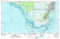
~ Miami FL topo map, 1:250000 scale, 1 X 2 Degree, Historical, 1956, updated 1973
Miami, Florida, USGS topographic map dated 1956.
Includes geographic coordinates (latitude and longitude). This topographic map is suitable for hiking, camping, and exploring, or framing it as a wall map.
Printed on-demand using high resolution imagery, on heavy weight and acid free paper, or alternatively on a variety of synthetic materials.
Topos available on paper, Waterproof, Poly, or Tyvek. Usually shipping rolled, unless combined with other folded maps in one order.
- Product Number: USGS-5621752
- Free digital map download (high-resolution, GeoPDF): Miami, Florida (file size: 21 MB)
- Map Size: please refer to the dimensions of the GeoPDF map above
- Weight (paper map): ca. 55 grams
- Map Type: POD USGS Topographic Map
- Map Series: HTMC
- Map Verison: Historical
- Cell ID: 68908
- Scan ID: 347470
- Imprint Year: 1973
- Woodland Tint: Yes
- Aerial Photo Year: 1970
- Edit Year: 1971
- Field Check Year: 1956
- Datum: Unstated
- Map Projection: Transverse Mercator
- Map published by: Military, Other
- Map Language: English
- Scanner Resolution: 600 dpi
- Map Cell Name: Miami
- Grid size: 1 X 2 Degree
- Date on map: 1956
- Map Scale: 1:250000
- Geographical region: Florida, United States
Neighboring Maps:
All neighboring USGS topo maps are available for sale online at a variety of scales.
Spatial coverage:
Topo map Miami, Florida, covers the geographical area associated the following places:
- Holiday Acres - North Bay Village - Lakes by the Bay - Palmetto Bay - Biscayne Park - Little Farm Mobile Court - Fronton Trailer Park - Glenvar Heights - Silver Palm Place - Hollywood Mobile Estates - Pembroke Park Lakes Mobile Home Park - Princeton - Blue Belle Trailer Park - Islandia - Aquarius Mobile Home Park - Green-Mar Acres - Little Farm Mobile Court - Peters - Sun Haven of Aventura - Medley Mobile Home Park - Tropical Trailer Village - Glenwood Heights - Cutler Bay - Silver Court Trailer Park - West Little River - Ojus - La Palm Trailer Park - Bal Harbour - Goodland - Gladeview - Chatham - Medley Lakeside Retirement Park - Fakahatchee - Carley's Mobile Home Park - The Pines - White House Trailer Park - Miami Heights Trailer Park - Garden Cove - Leon Hamilton Place - Hallandale Beach - Sunny Isles Beach - Hibiscus Point Mobile Home Park - Andover Lakes Estates - Virginia Gardens - Lindgren Acres - New Avocado Trailer Park - Andover - Haven Lake Estates Mobile Home Park - Dynamite Docks - Fisher Island - Silver Court Trailer Park - Paradise Point Mobile Home Park - Miami Gardens - Perrine - Cutler - Sweetwater - Plantation Island - Lemon City - Gold Key - Coconut Grove - Normandy Shores - Chokoloskee - Parkside Mobile Home Park - Landmark Mobile Home Park - South Miami Heights - The Board Walk Mobile Home Park - Buena Vista - Schmidts Adult Mobile Home Park - Bayshore - Golden Isles - Homestead Trailer Park - Highland Lakes - Tradewinds Trailer Park - Hibiscus Mobile Homes - Dixie Trailer Park - Hollywood Ridge Farms - Utopia - Beverley Beach - Sunset - Lake Forest - Trailtown - Miami Terrace Mobile Home - Westchester - Latin Quarter - Mart Law Seminole Village - Scott Lake - Miami Beach - Country Club - J Bar J Trailer Ranch - Sunrise Harbor - Deering Bay - Sixth Avenue Trailer Park - Sun Swept Isles - Golden Shores - Cutler Ridge - Dale Village Mobile Home Park - Paradise Trailer Park - Golden Beach - Grocery Place - Strawberry Village Trailer Park
- Map Area ID: AREA2625-82-80
- Northwest corner Lat/Long code: USGSNW26-82
- Northeast corner Lat/Long code: USGSNE26-80
- Southwest corner Lat/Long code: USGSSW25-82
- Southeast corner Lat/Long code: USGSSE25-80
- Northern map edge Latitude: 26
- Southern map edge Latitude: 25
- Western map edge Longitude: -82
- Eastern map edge Longitude: -80


