
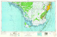
~ Miami FL topo map, 1:250000 scale, 1 X 2 Degree, Historical, 1956, updated 1963
Miami, Florida, USGS topographic map dated 1956.
Includes geographic coordinates (latitude and longitude). This topographic map is suitable for hiking, camping, and exploring, or framing it as a wall map.
Printed on-demand using high resolution imagery, on heavy weight and acid free paper, or alternatively on a variety of synthetic materials.
Topos available on paper, Waterproof, Poly, or Tyvek. Usually shipping rolled, unless combined with other folded maps in one order.
- Product Number: USGS-5621746
- Free digital map download (high-resolution, GeoPDF): Miami, Florida (file size: 13 MB)
- Map Size: please refer to the dimensions of the GeoPDF map above
- Weight (paper map): ca. 55 grams
- Map Type: POD USGS Topographic Map
- Map Series: HTMC
- Map Verison: Historical
- Cell ID: 68908
- Scan ID: 347466
- Imprint Year: 1963
- Woodland Tint: Yes
- Edit Year: 1962
- Field Check Year: 1956
- Datum: Unstated
- Map Projection: Transverse Mercator
- Map published by United States Geological Survey
- Map published by United States Army Corps of Engineers
- Map published by United States Army
- Map Language: English
- Scanner Resolution: 600 dpi
- Map Cell Name: Miami
- Grid size: 1 X 2 Degree
- Date on map: 1956
- Map Scale: 1:250000
- Geographical region: Florida, United States
Neighboring Maps:
All neighboring USGS topo maps are available for sale online at a variety of scales.
Spatial coverage:
Topo map Miami, Florida, covers the geographical area associated the following places:
- Hialeah Trailer Park - River Park Trailer Park - Royal Palm Hammock - Gateway Estates - Thompson - Rock Harbor Marina East Mobile Home Park - Brickell Hammock - Tower Mobile Home Park - Parkside Mobile Home Park - Coconut Grove - Travel Trailer Town - West Perrine - Isla Gold Mobile Home Park - Silver Palm Place - Pinewood - Pine Isle Mobile Home Park - South Miami - Latin Quarter - Goldcoaster Mobile Home Park - Princeton - Palm Trailer Park - Magic City Trailer Park - Trail City - Gulfstream Trailer Park - Royal Colonial Mobile - Opa-locka - Flamingo - Coastal Waterway Park Mobile Home Park - Andover - Bal Harbor Beach - Homestead Trailer Park - Buena Vista - Inlikita - Suniland - Deering Bay - Homestead Trailer Park - Kendale Lakes - The Board Walk Mobile Home Park - Emerald Isles East Mobile Home Park - Bell Haven Mobile Home Park - Little Farm Mobile Court - The Roads - Manatee Cove Mobile Home Park - North Key Largo - Miami Terrace Mobile Home - Nelson Mobile Home Park - Honey Hill Mobile Home Park - Palm Garden Manufactured Home Community - Franjo - Scott Lake - South Allapattah - Palm Trailer Park - Four Seasons Mobile Home Park - Leon Hamilton Place - Orange Brook Mobile Home Estates - Miramar - Miami Gardens - Country Walk - Kendall - Dynamite Docks - Doral - Royal Palm Mobile Home Park - Tavernier - Indian Creek Village - Sunny Isles Beach - Riviera Park Mobile Home Park - Miami Gardens - La Siesta Mobile Home Park - Coral Gables - Saga Bay - Westgate - North Bay Village - Peters - North Miami - Rovell Mobile Home Park - Isles of Capri - Mickey's Mobile Home Park - Cutler - Cutler Ridge - Three Lakes - Hialeah Estates - Carley's Mobile Home Park - Bayshore - Lone Pines Mobile Village - Hollywood Ridge Farms - Landmark Mobile Home Park - Adirondack Trailer Park - Lakes by the Bay - Westland Mobile Home Park - Glenvar Heights - The Pines - Kings Bay - All Star 36 Street Mobile Home Park - Keystone Islands - River Park Trailer Park - Homestead - Royal Duke Trailer Court - Smallpox Tommies Old Place - Normandy Shores - Riviera Mobile Park
- Map Area ID: AREA2625-82-80
- Northwest corner Lat/Long code: USGSNW26-82
- Northeast corner Lat/Long code: USGSNE26-80
- Southwest corner Lat/Long code: USGSSW25-82
- Southeast corner Lat/Long code: USGSSE25-80
- Northern map edge Latitude: 26
- Southern map edge Latitude: 25
- Western map edge Longitude: -82
- Eastern map edge Longitude: -80


