
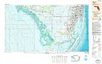
~ Miami FL topo map, 1:250000 scale, 1 X 2 Degree, Historical, 1988, updated 1988
Miami, Florida, USGS topographic map dated 1988.
Includes geographic coordinates (latitude and longitude). This topographic map is suitable for hiking, camping, and exploring, or framing it as a wall map.
Printed on-demand using high resolution imagery, on heavy weight and acid free paper, or alternatively on a variety of synthetic materials.
Topos available on paper, Waterproof, Poly, or Tyvek. Usually shipping rolled, unless combined with other folded maps in one order.
- Product Number: USGS-5621744
- Free digital map download (high-resolution, GeoPDF): Miami, Florida (file size: 23 MB)
- Map Size: please refer to the dimensions of the GeoPDF map above
- Weight (paper map): ca. 55 grams
- Map Type: POD USGS Topographic Map
- Map Series: HTMC
- Map Verison: Historical
- Cell ID: 68908
- Scan ID: 347465
- Imprint Year: 1988
- Woodland Tint: Yes
- Aerial Photo Year: 1986
- Edit Year: 1988
- Datum: NAD27
- Map Projection: Universal Transverse Mercator
- Map published by United States Geological Survey
- Map Language: English
- Scanner Resolution: 600 dpi
- Map Cell Name: Miami
- Grid size: 1 X 2 Degree
- Date on map: 1988
- Map Scale: 1:250000
- Geographical region: Florida, United States
Neighboring Maps:
All neighboring USGS topo maps are available for sale online at a variety of scales.
Spatial coverage:
Topo map Miami, Florida, covers the geographical area associated the following places:
- Sunrise Village Mobile Home Park - Sunset Point - Royal Colonial Mobile - Holiday Acres - Trailtown - West Little River - Miami Gardens - Goldcoaster Mobile Home Park - Leisure City - Royal Duke Trailer Court - Ocean View Heights - Riptide Trailer Park - Shenandoah - Homestead Trailer Park - Rockdale - Miami Shores - Trailer Grove Mobile Home Park - Aladdin City - Trinidad Court Mobile Home Park - Gladeview - Royal Palm Mobile Home Park - Hollywood Ridge Farms - Biscayne Park Mobile Home Park - Biscayne Breeze Park Mobile Home Park - Biscayne Gardens - Surfside - Leisure Mobile Home Park-Modello Park - Leisure Mobile Park - Royal Country Mobile Home Park - Flagami - North Miami Trailer Park - North Miami - Andover - Coopertown - Blue Belle Trailer Park - Goulds - Golden Shores - Normandy Shores - Sun Haven of Aventura - Interama - Glenwood Heights - Hialeah Trailer Park - Travel Trailer Town - West Perrine - Dynamite Docks - Brownsville - Miami Gardens - Courtly Manor - Westwood Lake - Inlikita - Old Grove - Andover Golf Estates - Bay Heights - Golden Glades - Medley Lakeside Retirement Park - Royal Palm Hammock - Sunset Corners - Pembroke Park Lakes Mobile Home Park - Kings Bay - New Avocado Trailer Park - Holiday Acres Mobile Home Park - Medley - Beverley Beach - Key Largo Park - Latin Quarter - Sunny Gardens Trailer Park - Palm Springs Estates - University Lakes Mobile Home Park - Medley Mobile Home Park - Coconut Grove - Paradise Trailer Park - Utopia - Town Park Estates - Miami Terrace Mobile Home - Sunny Isles Beach - Chatham - Palmetto Estates - Garden Cove - Anchor Mobile Home Park - Lil Abner Mobile Home Park - West Miami - Bobs Mobile Home Park - Westgate - Deering Bay - Everglades City - Trail Center - Palm Trailer Park - Sun Swept Isles - Carol City - Saga Bay - Atlantic Heights - Cutter Bank - Jerome - Grocery Place - Palm Lake Mobile Home Park - Adirondack Trailer Park - Little River M and M Mobile Home Park - Pops Hammock Seminole Village - Hialeah Gardens - White House Trailer Park
- Map Area ID: AREA2625-82-80
- Northwest corner Lat/Long code: USGSNW26-82
- Northeast corner Lat/Long code: USGSNE26-80
- Southwest corner Lat/Long code: USGSSW25-82
- Southeast corner Lat/Long code: USGSSE25-80
- Northern map edge Latitude: 26
- Southern map edge Latitude: 25
- Western map edge Longitude: -82
- Eastern map edge Longitude: -80


