
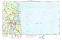
~ Jacksonville FL topo map, 1:250000 scale, 1 X 2 Degree, Historical, 1957, updated 1984
Jacksonville, Florida, USGS topographic map dated 1957.
Includes geographic coordinates (latitude and longitude). This topographic map is suitable for hiking, camping, and exploring, or framing it as a wall map.
Printed on-demand using high resolution imagery, on heavy weight and acid free paper, or alternatively on a variety of synthetic materials.
Topos available on paper, Waterproof, Poly, or Tyvek. Usually shipping rolled, unless combined with other folded maps in one order.
- Product Number: USGS-5621740
- Free digital map download (high-resolution, GeoPDF): Jacksonville, Florida (file size: 19 MB)
- Map Size: please refer to the dimensions of the GeoPDF map above
- Weight (paper map): ca. 55 grams
- Map Type: POD USGS Topographic Map
- Map Series: HTMC
- Map Verison: Historical
- Cell ID: 68840
- Scan ID: 346822
- Imprint Year: 1984
- Woodland Tint: Yes
- Edit Year: 1966
- Field Check Year: 1957
- Datum: Unstated
- Map Projection: Transverse Mercator
- Map published by United States Army Corps of Engineers
- Map published by United States Army
- Map Language: English
- Scanner Resolution: 600 dpi
- Map Cell Name: Jacksonville
- Grid size: 1 X 2 Degree
- Date on map: 1957
- Map Scale: 1:250000
- Geographical region: Florida, United States
Neighboring Maps:
All neighboring USGS topo maps are available for sale online at a variety of scales.
Spatial coverage:
Topo map Jacksonville, Florida, covers the geographical area associated the following places:
- Silver Dolphin Mobile Home Park - Hyde Park - Three Seasons Mobile Home Village - High Point - Dyal - Ortega Forest - Hilden - Tolomato (historical) - Alcoy Road Mobile Home Park - Magnolia Circle Manufactured Home Community - Pablo Keys - Taylor Mobile Home Park - Duval - Westwood - Shadowland - Sundown Estates Mobile Home Park - Beacon Hills - Bryceville - Holly Ford - Fleetwood Mobile Home Park - San Jose - Fort George Island - Rhondas Trailer Park - Cedar Hills Estates - Eggleston Heights - Riverside - Holiday Hill - Atlantic Village Mobile Home Park - Carr Mobile Home Village - Lake Forest Manor - Manhattan Beach - Camden Point Mobile Home Park - Deerwood Club - Lakewood - Sampson - Verdie - Harrietts Bluff - Hyde Grove - Garden City - Country Roads Mobile Home Community - Pearl Court - Neilhurst - Twentymile - Greentree - Brightsville - Marshall Plantation (historical) - Doctors Inlet - Saint Nicholas - Beverly Hills - Harrietts Bluff Village - Continental Village Mobile Home Park - Lands End - Holiday Harbor - Murray Hill - Beauclerc - Biltmore - Plantation Oaks - Biltmore - Brooklyn - Crandall - South Jacksonville - Oak Landing - Arlington - Center Park - Bellair - Colesburg - Grand Park - Atlantic Beach - Marianna (historical) - Leon Mobile Home Park - Orangedale - Jacksonville - Springfield - Oceanway Village Mobile Home Park - Dewey Park - Deals Landing - Joels Landing - American Beach - Hogan - Middleburg - Mayport - Riverview - Vacuna (historical) - San Diego Salamototo (historical) - Circle Eleven Mobile Home Park - East Mandarin - Shady Oak Mobile Home Park - Orange Park North Mobile Home Community - Forestview - Billyville - Southside Mobile Home Park - Philips - Pinehurst - Mayport Mobile Home Park - Ponte Vedra - Glenwood - Creekwood - Goodbys - Brookview Trailer Park - Riverview
- Map Area ID: AREA3130-82-80
- Northwest corner Lat/Long code: USGSNW31-82
- Northeast corner Lat/Long code: USGSNE31-80
- Southwest corner Lat/Long code: USGSSW30-82
- Southeast corner Lat/Long code: USGSSE30-80
- Northern map edge Latitude: 31
- Southern map edge Latitude: 30
- Western map edge Longitude: -82
- Eastern map edge Longitude: -80


