
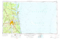
~ Jacksonville FL topo map, 1:250000 scale, 1 X 2 Degree, Historical, 1957, updated 1974
Jacksonville, Florida, USGS topographic map dated 1957.
Includes geographic coordinates (latitude and longitude). This topographic map is suitable for hiking, camping, and exploring, or framing it as a wall map.
Printed on-demand using high resolution imagery, on heavy weight and acid free paper, or alternatively on a variety of synthetic materials.
Topos available on paper, Waterproof, Poly, or Tyvek. Usually shipping rolled, unless combined with other folded maps in one order.
- Product Number: USGS-5621736
- Free digital map download (high-resolution, GeoPDF): Jacksonville, Florida (file size: 13 MB)
- Map Size: please refer to the dimensions of the GeoPDF map above
- Weight (paper map): ca. 55 grams
- Map Type: POD USGS Topographic Map
- Map Series: HTMC
- Map Verison: Historical
- Cell ID: 68840
- Scan ID: 346820
- Imprint Year: 1974
- Woodland Tint: Yes
- Edit Year: 1966
- Field Check Year: 1957
- Datum: Unstated
- Map Projection: Transverse Mercator
- Map published by United States Army Corps of Engineers
- Map published by United States Army
- Map Language: English
- Scanner Resolution: 600 dpi
- Map Cell Name: Jacksonville
- Grid size: 1 X 2 Degree
- Date on map: 1957
- Map Scale: 1:250000
- Geographical region: Florida, United States
Neighboring Maps:
All neighboring USGS topo maps are available for sale online at a variety of scales.
Spatial coverage:
Topo map Jacksonville, Florida, covers the geographical area associated the following places:
- Woodstock (historical) - Hatch Road Mobile Home Park - Golfair Trailer Park - River Cove - Normandy - Kent - Kings Ferry - East Mayport (historical) - Hilliard - Bell View (historical) - Beacon Hills - Camp Pinkney (historical) - Cabin Bluff - Holiday Harbor - Switzerland - Caleb - Tompkins - Durbin - Palmetto Pines Mobile Home Park - Dardens Mobile Home Park - Circle Eleven Mobile Home Park - Oak Hill - Biltmore - Sadlers Cove - Oaks of Atlantic Beach Mobile Home Park - Leon Mobile Home Park - Beeghly Heights - Orange Park North Mobile Home Community - Oaks Mobile Home Court - Forest Ridge - Boulogne - Whispering Pines Trailer Park - Deloach Trailer Park - Edgewood - Camp Echockotee - Atlantic Beach - Fort Caroline - Carver Manor - Magnolia Circle Manufactured Home Community - Mandeville - Mays Bluff - Hyde Park - Fort George Island - Greenfield - Old Amelia Mobile Home Park - Prescott (historical) - Jacksonville Beach - Highland Oaks - Spring Glen - Floral Bluff - Plantation Point - Brothers Mobile Home Park - Cambon - Halsema - High Point - Beauclerc - Pecan Park - Lake Forest - Martin Glen - Sandalwood - Woodhaven - River Oaks - Clarksville - Pine Villa Mobile Home Park - Sweetwater - Refuge (historical) - Ratliff - Clarks Bluff - Buccaneer Mobile Home Park - Mayport Mobile Home Park - Deerwood Club - Oceanway - Hilden - San Pablo - Sunbeam - Mariners Landing - Dyal - O'Neil - Southern Pines Mobile Home Park - Pinehurst - Centerville (historical) - Hewitt Street Mobile Home Park - May Creek - Hibernia - South Ponte Vedra Beach - Middleburg - Goodbread Mobile Home Park - Meadowbrook Terrace - Pine Breeze Mobile Home Park - Donner - Spaulding - Sans Pareil - West Jacksonville - Bristol Hammock - Southridge - Cedar Hills - Catfish Acres - Grazing Meadows Mobile Home Village - Killarney Shores - San Diego Salamototo (historical)
- Map Area ID: AREA3130-82-80
- Northwest corner Lat/Long code: USGSNW31-82
- Northeast corner Lat/Long code: USGSNE31-80
- Southwest corner Lat/Long code: USGSSW30-82
- Southeast corner Lat/Long code: USGSSE30-80
- Northern map edge Latitude: 31
- Southern map edge Latitude: 30
- Western map edge Longitude: -82
- Eastern map edge Longitude: -80


