
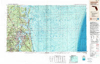
~ Jacksonville FL topo map, 1:250000 scale, 1 X 2 Degree, Historical, 1988, updated 1988
Jacksonville, Florida, USGS topographic map dated 1988.
Includes geographic coordinates (latitude and longitude). This topographic map is suitable for hiking, camping, and exploring, or framing it as a wall map.
Printed on-demand using high resolution imagery, on heavy weight and acid free paper, or alternatively on a variety of synthetic materials.
Topos available on paper, Waterproof, Poly, or Tyvek. Usually shipping rolled, unless combined with other folded maps in one order.
- Product Number: USGS-5621730
- Free digital map download (high-resolution, GeoPDF): Jacksonville, Florida (file size: 29 MB)
- Map Size: please refer to the dimensions of the GeoPDF map above
- Weight (paper map): ca. 55 grams
- Map Type: POD USGS Topographic Map
- Map Series: HTMC
- Map Verison: Historical
- Cell ID: 68840
- Scan ID: 346817
- Imprint Year: 1988
- Woodland Tint: Yes
- Aerial Photo Year: 1984
- Edit Year: 1988
- Datum: NAD27
- Map Projection: Universal Transverse Mercator
- Map published by United States Geological Survey
- Map Language: English
- Scanner Resolution: 600 dpi
- Map Cell Name: Jacksonville
- Grid size: 1 X 2 Degree
- Date on map: 1988
- Map Scale: 1:250000
- Geographical region: Florida, United States
Neighboring Maps:
All neighboring USGS topo maps are available for sale online at a variety of scales.
Spatial coverage:
Topo map Jacksonville, Florida, covers the geographical area associated the following places:
- San Nicolas Palica (historical) - Switzerland - Laurel Grove - Normandy Village - Holly Point - Camp Echockotee - North Oak Hill - London Hill - Orangedale - Lake Forest Hills - Becker - Westwood - Palm Valley Landing - Bryceville - Ortega Farms - Oakhurst - Italia - Halifax - Allens Mobile Home Park - Pineland Gardens Trailer Park - Clayton Estates Mobile Home Park - Grover View - Mariners Landing - Clarksville - Dunn Creek - Woodstock (historical) - Saint Marys - Pine Oaks Mobile Home Park - Magnolia Circle Manufactured Home Community - Murray Hill - Holiday Harbor - Portside Mobile Home Park - Elliotts Bluff - Nassauville - Briarwood Mobile Home Park - Study Estates Mobile Home Park - River Oaks at Harrietts Bluff - Dames Point Manor - Refuge (historical) - Country Roads Mobile Home Community - Connie Jean Mobile Home Park - Deloach Trailer Park - Runnymeade - Shady Rest - Pearl Court - Billyville - Atlantic Beach - Silver Dolphin Mobile Home Park - Mayport - Philips - Loretto - West Jacksonville - Eggleston Heights - Brightsville - Isle of Palms - Bristol Hammock - Mayport Mobile Home Park - Chester - Sandalwood - Biltmore - Springfield - Trailer Terrace Mobile Home Park - Orange Park - Beechwood - Ruby's Mobile Home Park - San Pablo Patali (historical) - Yulee - South Ponte Vedra Beach - East Mayport - Oak Harbor - Carr Mobile Home Village - Hopewell - Plantation Oaks - May Creek - Cambon - Manhattan Beach - Mickler Landing - Yukon - Sugar Mill Plantation - Talleyrand - Harrietts Bluff Village - Woodland Estates Mobile Home Park - Brookview Trailer Park - Fruit Cove - Deals Landing - Rains Landing - Northwood - Yulee Heights - Old Amelia Mobile Home Park - Lake Forest Hills - Oak Hill Park - Stockade - North Meadowbrook Terrace - Meadowbrook Terrace - Crystal Oaks Mobile Home Park - Sans Pareil - Cedar Hills Estates - Greentree - Riverview - Quail Hollow
- Map Area ID: AREA3130-82-80
- Northwest corner Lat/Long code: USGSNW31-82
- Northeast corner Lat/Long code: USGSNE31-80
- Southwest corner Lat/Long code: USGSSW30-82
- Southeast corner Lat/Long code: USGSSE30-80
- Northern map edge Latitude: 31
- Southern map edge Latitude: 30
- Western map edge Longitude: -82
- Eastern map edge Longitude: -80


