
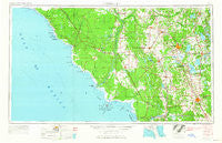
~ Gainesville FL topo map, 1:250000 scale, 1 X 2 Degree, Historical, 1954, updated 1965
Gainesville, Florida, USGS topographic map dated 1954.
Includes geographic coordinates (latitude and longitude). This topographic map is suitable for hiking, camping, and exploring, or framing it as a wall map.
Printed on-demand using high resolution imagery, on heavy weight and acid free paper, or alternatively on a variety of synthetic materials.
Topos available on paper, Waterproof, Poly, or Tyvek. Usually shipping rolled, unless combined with other folded maps in one order.
- Product Number: USGS-5621724
- Free digital map download (high-resolution, GeoPDF): Gainesville, Florida (file size: 13 MB)
- Map Size: please refer to the dimensions of the GeoPDF map above
- Weight (paper map): ca. 55 grams
- Map Type: POD USGS Topographic Map
- Map Series: HTMC
- Map Verison: Historical
- Cell ID: 68794
- Scan ID: 346372
- Imprint Year: 1965
- Woodland Tint: Yes
- Edit Year: 1964
- Field Check Year: 1954
- Datum: Unstated
- Map Projection: Transverse Mercator
- Map published by United States Army Corps of Engineers
- Map published by United States Army
- Map Language: English
- Scanner Resolution: 600 dpi
- Map Cell Name: Gainesville
- Grid size: 1 X 2 Degree
- Date on map: 1954
- Map Scale: 1:250000
- Geographical region: Florida, United States
Neighboring Maps:
All neighboring USGS topo maps are available for sale online at a variety of scales.
Spatial coverage:
Topo map Gainesville, Florida, covers the geographical area associated the following places:
- Autumn Leaves Mobile Home Park - Old Town - Fort White - Ocala Waterway - Lakeview Estates - Olin's Mobile Home Park - Theressa - Belleview - Otter Creek - Los Trancos Woods - New River - Huntington - Pine Village Mobile Home Park - Jena - Monteocha - Cedar Grove Mobile Home Park - Sweetwater Oaks Mobile Home Park - Andrews - Sumner - Eugene - Cyrs Mobile Home Park - Hardeetown - Lincoln Estates - Oakwood Mobile Manor Mobile Home Park - Adam - Dallus Creek Landing - Yankeetown - Graham - Zuber - Morriston - Traxler - Rolling Ranches - Citra - Gateway Mobile Home Park - Mount Olive - Starke - Thames - Sparr - Merediths - Hague - Clark - Clara - Haile - Kingsley Village - Chiefland - Clifton Mobile City Mobile Home Park - Crackertown - Orange Lake - Kincaid Hills - Phifer - Dana - Santos Mobile Home Park - Campville - McMeekin - Regal Park - Craggs - Idylwild - Ocala Ridge - Hines - La Crosse - Alachua II (historical) - Browns Still - Steinhatchee - Whispering Pines Commmunity Mobile Home Park - Rolling Greens Mobile Home Park - Romeo - Clayton Estates Mobile Home Park - Broscan - Nautilus Trailer Park - Golden Hills Park Mobile Home Park - Trenton - Keystone Heights - Saddle Oak Club Mobile Home Park - Shady Road Villas Mobile Home Park - Jonesville - Oak Park Village Mobile Home Park - Tacoma - Shady Acres Adult Mobile Home Park - Durant Estates - Fairfield Village of Ocala Mobile Home Park - Rosewood - Boardman - Oak - Salem - Lowell - Bahia Oaks - Meadow Lark Mobile Home Park - Stewart City - Beech Creek (historical) - Santa Fe - Orange Heights - Santos - Ellzey - Varsity Mobile Home Villa - Shady Grove Mobile Home Park - Robinson Heights - Compton Mobile Home Park - Millwood - Fairbanks - Westgate Mobile Manor
- Map Area ID: AREA3029-84-82
- Northwest corner Lat/Long code: USGSNW30-84
- Northeast corner Lat/Long code: USGSNE30-82
- Southwest corner Lat/Long code: USGSSW29-84
- Southeast corner Lat/Long code: USGSSE29-82
- Northern map edge Latitude: 30
- Southern map edge Latitude: 29
- Western map edge Longitude: -84
- Eastern map edge Longitude: -82


