
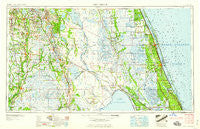
~ Fort Pierce FL topo map, 1:250000 scale, 1 X 2 Degree, Historical, 1959, updated 1959
Fort Pierce, Florida, USGS topographic map dated 1959.
Includes geographic coordinates (latitude and longitude). This topographic map is suitable for hiking, camping, and exploring, or framing it as a wall map.
Printed on-demand using high resolution imagery, on heavy weight and acid free paper, or alternatively on a variety of synthetic materials.
Topos available on paper, Waterproof, Poly, or Tyvek. Usually shipping rolled, unless combined with other folded maps in one order.
- Product Number: USGS-5621710
- Free digital map download (high-resolution, GeoPDF): Fort Pierce, Florida (file size: 16 MB)
- Map Size: please refer to the dimensions of the GeoPDF map above
- Weight (paper map): ca. 55 grams
- Map Type: POD USGS Topographic Map
- Map Series: HTMC
- Map Verison: Historical
- Cell ID: 68784
- Scan ID: 346308
- Imprint Year: 1959
- Woodland Tint: Yes
- Field Check Year: 1956
- Datum: Unstated
- Map Projection: Transverse Mercator
- Map published by United States Army Corps of Engineers
- Map published by United States Army
- Map Language: English
- Scanner Resolution: 600 dpi
- Map Cell Name: Fort Pierce
- Grid size: 1 X 2 Degree
- Date on map: 1959
- Map Scale: 1:250000
- Geographical region: Florida, United States
Neighboring Maps:
All neighboring USGS topo maps are available for sale online at a variety of scales.
Spatial coverage:
Topo map Fort Pierce, Florida, covers the geographical area associated the following places:
- Little Gator Park Mobile Home Park - Southern Comfort Mobile Home Park - Fort Green Springs - Park Place Mobile Home Park - Maxcy Quarters - Medulla - Palm Village Mobile Home Park - Snug Harbor - Roux Quarters - Hammock Lake Mobile Estates - Kinsey - Maggie Runyon Trailer Park - Whispering Pines - Lake Garfield - Highland Park - Ocean Breeze Park - Avon Park - Micco - Southern Pines Mobile Home Resort - Tropical Park - Lake Glenada Mobile Home Park - Sherman - Fort Basinger - Neilson - Gordonville - Lakemont - Pinelake Gardens Estates - Oakview Lakes Mobile Home Park - White City - Floridana Beach - Sebring Mobile Estates - Rosemont Mobile Home Park - River Park - Taylor Creek Lodge Mobile Home Park - Indian Lake Estates - Pierce - Fort Ogden - Grove Park Lane Mobile Home Park - Marina Cove Mobile Home Park - Cornwell - Fruita - S P Mobile Home Park - Eighth Street Mobile Home Park - Oak Gardens Mobile Home Park - Coker - Eagle Island - Mountain Lake Station - Baird - Braswells Heritage Estates Mobile Home Park - Fischer's Corner Trailer Park - Connecticut Mobile Park - Fedhaven - Vantage Oaks Mobile Home Park - Royal Poinciana Park - Okeechobee - Lake Marian Highlands - Hebel Acres Mobile Home Park - Selph's Mobile Home Village - Sand Hill Mobile Home Park - Sheltras Trailer Park - Lemon Grove - Lake Bonnet Village Mobile Home Park - Desoto Mobile Home Park - 46th Avenue Villas Mobile Home Park - Wabasso - Grape Hammock Mobile Home Park - Orange Manor Mobile Home Park West - Bartow Mobile Home Park - Country Trailer Park - Lake Clinch Manor Mobile Home Park - Pine Dale - Lighthouse Point - Rainbow Trailer Park - Stephen's Winter Resort Mobile Home Park - Valencia Mobile Home Park - Chelette Manor Mobile Home Park - The Highlander Mobile Home Court - Lighthouse Park Mobile Home Park - Archbold - Country Cove Mobile Home Community - Countryside at Vero Beach Mobile Home Park - Gator Park Mobile Home Park - Childs - Crawfords Trailer Park - The Harbor Mobile Home Park - Fort Meade - Tangelo Village Mobile Home Park - Southland Mobile Home Park - Whidden Mobile Home Park - Eloise - S and K Mobile Home Park - Jackson Creek Mobile Estates - Lake Redwater Mobile Home Park - Dexter Shores Mobile Park - Oponys Town (historical) - Royster - Lily - Lowes Mobile Home Park - River Grove Mobile Home Village - Southfort
- Map Area ID: AREA2827-82-80
- Northwest corner Lat/Long code: USGSNW28-82
- Northeast corner Lat/Long code: USGSNE28-80
- Southwest corner Lat/Long code: USGSSW27-82
- Southeast corner Lat/Long code: USGSSE27-80
- Northern map edge Latitude: 28
- Southern map edge Latitude: 27
- Western map edge Longitude: -82
- Eastern map edge Longitude: -80


