
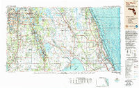
~ Fort Pierce FL topo map, 1:250000 scale, 1 X 2 Degree, Historical, 1988, updated 1988
Fort Pierce, Florida, USGS topographic map dated 1988.
Includes geographic coordinates (latitude and longitude). This topographic map is suitable for hiking, camping, and exploring, or framing it as a wall map.
Printed on-demand using high resolution imagery, on heavy weight and acid free paper, or alternatively on a variety of synthetic materials.
Topos available on paper, Waterproof, Poly, or Tyvek. Usually shipping rolled, unless combined with other folded maps in one order.
- Product Number: USGS-5621708
- Free digital map download (high-resolution, GeoPDF): Fort Pierce, Florida (file size: 22 MB)
- Map Size: please refer to the dimensions of the GeoPDF map above
- Weight (paper map): ca. 55 grams
- Map Type: POD USGS Topographic Map
- Map Series: HTMC
- Map Verison: Historical
- Cell ID: 68784
- Scan ID: 346307
- Imprint Year: 1988
- Woodland Tint: Yes
- Aerial Photo Year: 1984
- Edit Year: 1988
- Datum: NAD27
- Map Projection: Universal Transverse Mercator
- Map published by United States Geological Survey
- Map Language: English
- Scanner Resolution: 600 dpi
- Map Cell Name: Fort Pierce
- Grid size: 1 X 2 Degree
- Date on map: 1988
- Map Scale: 1:250000
- Geographical region: Florida, United States
Neighboring Maps:
All neighboring USGS topo maps are available for sale online at a variety of scales.
Spatial coverage:
Topo map Fort Pierce, Florida, covers the geographical area associated the following places:
- Hen Scratch - Vero Palm Estates - Woodlawn Manor Mobile Home Park - Homeland - Breezeway Mobile Home Park - Squire Village Mobile Home Park - Mildred - Hesperides - Mulberry - Indian River Shores - North River Shores - Sunrise Mobile Home Park - Avon Mobile Home Park - Floridana Beach - Indian River Shores Trailer Court - Zana - Gomez - Pine Dale - White City - Okeechobee - Thunderbird Hills South Mobile Home Park - Fuller Heights - Palm Lake Club Mobile Home Park - Lowes Mobile Home Park - Vero Beach - Johnsons Trailer Park - Yeehaw Junction - Hebel Acres Mobile Home Park - Tangelo Village Mobile Home Park - Grace Mobile Home Park - Grove Park Lane Mobile Home Park - Peace River Shores - Seminole Village Mobile Home Park - Pittsburg - Villa Margaret Trailer Park - Orange Manor Mobile Home Park West - Sunrise Trailer Park - Windsong Mobile Village - Country Trailer Park - Evans Pines - Spanish Lakes Country Club Village Mobile Home Park - Sewall's Point - Avon Park Lakes - Kuhlman - Buttonwood Bay Mobile Home Park - Indiantown - Braswells Heritage Estates Mobile Home Park - Port Sewall - Whispering Pines Mobile Home Court - Marland - Collins Park Estates - Tanglewood Village Mobile Home Park - Leisure Village Mobile Home Park - Maxcy Quarters - Terio's Mobile Home Park - Torrey - Basinger - Pine Level - Sarasota Colony - Gordonville - Fort Kissimmee - Pelican Bay Manufactured Home Community - Town and Country Mobile Home Park - Town and Country Mobile Home Park - Alturas - Oak Gardens Mobile Home Park - Sebring Shores - Sparkman - Jensen Beach - Orchid - Orange Manor Mobile Home Park East - Southern Comfort Mobile Home Park - Gloria Park Mobile Home Park - La Buona Vita Mobile Home Park - Ranchland Mobile Home Park - Baird - Whispering Pines - S P Mobile Home Park - Seminole Shores - Countryside Mobile Home Park - Cypress Knee Cove Mobile Home Park - Paradise Park - Salerno Trailer Park - Indianwood Manufactured Housing Community - Walton - Francis I Mobile Estates - Southern Pines Recreational Vehicle Park - Palm Vista Mobile Ranch - Oak Grove - Lindale Mobile Home Park - Floritan - Joshua - Highland Village Mobile Home Park - Doans Mobile Home Park - Archbold - Crooked Lake Park - Harrys Harbor Mobile Home Park - Maggie Runyon Trailer Park - Hicoria - Highland Lakes
- Map Area ID: AREA2827-82-80
- Northwest corner Lat/Long code: USGSNW28-82
- Northeast corner Lat/Long code: USGSNE28-80
- Southwest corner Lat/Long code: USGSSW27-82
- Southeast corner Lat/Long code: USGSSE27-80
- Northern map edge Latitude: 28
- Southern map edge Latitude: 27
- Western map edge Longitude: -82
- Eastern map edge Longitude: -80


