
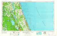
~ Daytona Beach FL topo map, 1:250000 scale, 1 X 2 Degree, Historical, 1964, updated 1964
Daytona Beach, Florida, USGS topographic map dated 1964.
Includes geographic coordinates (latitude and longitude). This topographic map is suitable for hiking, camping, and exploring, or framing it as a wall map.
Printed on-demand using high resolution imagery, on heavy weight and acid free paper, or alternatively on a variety of synthetic materials.
Topos available on paper, Waterproof, Poly, or Tyvek. Usually shipping rolled, unless combined with other folded maps in one order.
- Product Number: USGS-5621704
- Free digital map download (high-resolution, GeoPDF): Daytona Beach, Florida (file size: 13 MB)
- Map Size: please refer to the dimensions of the GeoPDF map above
- Weight (paper map): ca. 55 grams
- Map Type: POD USGS Topographic Map
- Map Series: HTMC
- Map Verison: Historical
- Cell ID: 68741
- Scan ID: 345757
- Imprint Year: 1964
- Woodland Tint: Yes
- Edit Year: 1964
- Field Check Year: 1954
- Datum: Unstated
- Map Projection: Transverse Mercator
- Map published by United States Army Corps of Engineers
- Map published by United States Army
- Map Language: English
- Scanner Resolution: 600 dpi
- Map Cell Name: Daytona Beach
- Grid size: 1 X 2 Degree
- Date on map: 1964
- Map Scale: 1:250000
- Geographical region: Florida, United States
Neighboring Maps:
All neighboring USGS topo maps are available for sale online at a variety of scales.
Spatial coverage:
Topo map Daytona Beach, Florida, covers the geographical area associated the following places:
- Brewers Landing - Moss Bluff - Holly Forest Estates Mobile Home Park - Francis - Daisy Lake - De Leon Springs Heights - Daytona Beach Shores - Leno - Smith Lake Shores Village Mobile Home Park - Tall Pines Mobile Home Park - Daytona Highridge Estates - Blairs Jungle Den Mobile Home Park - Coquina Crossing Mobile Home Park - Rice Creek - Halifax Estates - Pocotalaco (historical) - South Daytona - Lutz Mobile Home Park - Graceland Mobile Home Park - Villa Farms Mobile Home Park - Ridgecrest Mobile Home Park - Crane Lakes Mobile Home Park - Lake Waldena Resort Mobile Home Park - Kingsley Mobile Home Park - Salt Springs Village Mobile Home Park - El Ray Trailer Park - Cooper L Hills Estates - Phoenix Estates Mobile Home Park - Forest Lakes Park - Daytona Park Estates - Belmore - Astor - Lake Crescent Mobile Home Park - Ponce Inlet - Teasdale - Baywood - Espanola - Green Cove Springs - Taylor Mobile Home Park - Sutherlands Still - Spring Garden Ranch Mobile Home Park - Palmo - Hide - a - Way Cove Mobile Home Park - Rollestown (historical) - Black Point - West Tocoi - Deep Woods Mobile Home Park - Patersonville - Orange Springs - Wilbur-by-the-Sea - Fort Peyton - Myrtle Island - Seville - Siesta Mobile Home Park - Live Oak Mobile Village - Royal Oak Trailer Park - Azalea Mobile Home Park North - Robin Hood Terrace Mobile Home Park - Bay Lake - Arroyo Mobile Home Park - Breeze Trailer Park - June Terrace Mobile Home Park - Yelvington - Whispering Oaks Gardens Mobile Home Park - Fairview - Idlewild Trailer Park - Bakersville - Cozy Trailer Park - Surfside Estates Mobile Home Park - Satsuma - Cozy Circle Trailer Park - Hammond - Whisperwood Manufactured Home Park - Lingering Lane Mobile Home Park - Brookwood Mobile Home Park - Mirror Lake Mobile Home Park - Nombre de Dios (historical) - Meldrim Park - Saybrook - Bull Creek Mobile Home Park - Conner - Ashland Mobile Home Park - Dimarco Trailer Park - Treasure Isle Estates Mobile Home Park - Samsula - New Smyrna Beach - Saint Augustine Family Park Mobile Home Park - Clay Landing - Parkwood Manufactured Home Community - Ra Mar Mobile Home Park - Seahorse Mobile Home Park - A Better Place Mobile Home Park - Grand View Grove - Town and Country Mobile Home Park - Beachwood Trailer Park - Possum Bluff - Easy Street Mobile Home Park - Life Mobile Home Park - Penney Farms - Oak Ridge Park
- Map Area ID: AREA3029-82-80
- Northwest corner Lat/Long code: USGSNW30-82
- Northeast corner Lat/Long code: USGSNE30-80
- Southwest corner Lat/Long code: USGSSW29-82
- Southeast corner Lat/Long code: USGSSE29-80
- Northern map edge Latitude: 30
- Southern map edge Latitude: 29
- Western map edge Longitude: -82
- Eastern map edge Longitude: -80


