
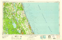
~ Daytona Beach FL topo map, 1:250000 scale, 1 X 2 Degree, Historical, 1958, updated 1958
Daytona Beach, Florida, USGS topographic map dated 1958.
Includes geographic coordinates (latitude and longitude). This topographic map is suitable for hiking, camping, and exploring, or framing it as a wall map.
Printed on-demand using high resolution imagery, on heavy weight and acid free paper, or alternatively on a variety of synthetic materials.
Topos available on paper, Waterproof, Poly, or Tyvek. Usually shipping rolled, unless combined with other folded maps in one order.
- Product Number: USGS-5621702
- Free digital map download (high-resolution, GeoPDF): Daytona Beach, Florida (file size: 13 MB)
- Map Size: please refer to the dimensions of the GeoPDF map above
- Weight (paper map): ca. 55 grams
- Map Type: POD USGS Topographic Map
- Map Series: HTMC
- Map Verison: Historical
- Cell ID: 68741
- Scan ID: 345756
- Imprint Year: 1958
- Woodland Tint: Yes
- Field Check Year: 1954
- Datum: Unstated
- Map Projection: Transverse Mercator
- Map published by United States Army Corps of Engineers
- Map published by United States Army
- Map Language: English
- Scanner Resolution: 600 dpi
- Map Cell Name: Daytona Beach
- Grid size: 1 X 2 Degree
- Date on map: 1958
- Map Scale: 1:250000
- Geographical region: Florida, United States
Neighboring Maps:
All neighboring USGS topo maps are available for sale online at a variety of scales.
Spatial coverage:
Topo map Daytona Beach, Florida, covers the geographical area associated the following places:
- Crescent City - Bass Capital Mobile Home Park - Mirror Lake Mobile Home Park - April Oaks Mobile Home Park - Armstrong - Ormond Beach - Sugar Mill Mobile Home Park - Halifax Estates - Bakerstown - Bunnell - Lutz Mobile Home Park - Kingsley Mobile Home Park - Frog Hollow Court Mobile Home Park - Buffalo Bluff - Lake Kathryn Heights - Bridgeport - Fort Brook Landing - Lundy - Molasses Junction - Casa Cola - Powells Campground Mobile Home Park - Hillside Trailer Park - Sutherlands Still - River Villas Manufactured Home Park - Point Pleasant - Andalusia - Camp Ocala - Whiteville - Seville - Newt's Trailer Park - Bardin - Whispering Oaks Gardens Mobile Home Park - Elmwood Mobile Home Park - Bluffton - Springside - Grandin - Emporia - Redland Estates Mobile Home Community - Lazy C Mobile Home Park - Saint Francis - Lake Dorr Mobile Home Park - Allandale Mobile Home Park - Deanville - East Lake Weir - Blue Villa Mobile Home Park - Lake in the Forest Estates Mobile Home Park - Carriage Cove Mobile Home Park - Hog Valley - Big Scrub - Lakeview Terrace Mobile Home Park - Grandview - Warwick Trailer Park - Deadman Landing - Salt Springs Village Mobile Home Park - Ezra's Landing Mobile Home Park - Eldridge - Davis Shores - Lake Weir Pines Mobile Home Park - Painters Hill - De Leon Springs - Orangewood Mobile Home Park - Cooper L Hills Estates - Huntington - Tall Timber Mobile Home Park - Salt Springs - Coquina Gables - Manhatten - Ocklawaha - Conner - Palmo - Beverly Beach - Lake Kathryn - Lynn - Saybrook - Bass Haven - Nombre de Dios (historical) - Pocotalaco (historical) - Astor Park - Easy Street Mobile Home Park - Cozy Trailer Park - Forest Corners - National Gardens - Pecan - Myrtle Island - Ponce Inlet - Bon Terra - Fernwood Mobile Home Park - Daytona Twin Oaks Mobile Home Park - Korona - Hill Creek Mobile Home Park - June Terrace Mobile Home Park - Blairs Jungle Den Mobile Home Park - Mosquito Grove - Ellinor Village - Bear Creek Mobile Home Park - Spring Garden Ranch Mobile Home Park - Sha De Land Mobile Home Park - Vilano Beach - Silver Lake Oaks Mobile Home Village - Hawthorne Hills of Deland Mobile Home Park
- Map Area ID: AREA3029-82-80
- Northwest corner Lat/Long code: USGSNW30-82
- Northeast corner Lat/Long code: USGSNE30-80
- Southwest corner Lat/Long code: USGSSW29-82
- Southeast corner Lat/Long code: USGSSE29-80
- Northern map edge Latitude: 30
- Southern map edge Latitude: 29
- Western map edge Longitude: -82
- Eastern map edge Longitude: -80


