
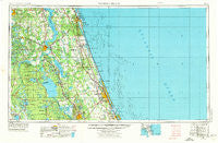
~ Daytona Beach FL topo map, 1:250000 scale, 1 X 2 Degree, Historical, 1954, updated 1974
Daytona Beach, Florida, USGS topographic map dated 1954.
Includes geographic coordinates (latitude and longitude). This topographic map is suitable for hiking, camping, and exploring, or framing it as a wall map.
Printed on-demand using high resolution imagery, on heavy weight and acid free paper, or alternatively on a variety of synthetic materials.
Topos available on paper, Waterproof, Poly, or Tyvek. Usually shipping rolled, unless combined with other folded maps in one order.
- Product Number: USGS-5621700
- Free digital map download (high-resolution, GeoPDF): Daytona Beach, Florida (file size: 21 MB)
- Map Size: please refer to the dimensions of the GeoPDF map above
- Weight (paper map): ca. 55 grams
- Map Type: POD USGS Topographic Map
- Map Series: HTMC
- Map Verison: Historical
- Cell ID: 68741
- Scan ID: 345755
- Imprint Year: 1974
- Woodland Tint: Yes
- Aerial Photo Year: 1972
- Edit Year: 1972
- Field Check Year: 1954
- Datum: Unstated
- Map Projection: Transverse Mercator
- Map published by United States Geological Survey
- Map Language: English
- Scanner Resolution: 600 dpi
- Map Cell Name: Daytona Beach
- Grid size: 1 X 2 Degree
- Date on map: 1954
- Map Scale: 1:250000
- Geographical region: Florida, United States
Neighboring Maps:
All neighboring USGS topo maps are available for sale online at a variety of scales.
Spatial coverage:
Topo map Daytona Beach, Florida, covers the geographical area associated the following places:
- Hide - a - Way Cove Mobile Home Park - Pocotalaco (historical) - Lynne - Vermont Heights - Moss Bluff - Lighthouse Pointe at Daytona Beach Mobile Home Park - Point Pleasant - Deadman Landing - Grandin - Crows Bluff - Beverly Beach Trailer Park - Satsuma - West Tocoi - Saint Francis - Nashua - Graceland Mobile Home Park - East Silver Springs Shore - Ormond-by-the-Sea - Breeze Trailer Park - Surfside Estates Mobile Home Park - Westwood Mobile Home Park - Bridgeport - New Run - Flagler Beach - June Terrace Mobile Home Park - Colonial Colony South Mobile Home Park - Buffalo Bluff - Mission City - Ezra's Landing Mobile Home Park - Azalea Mobile Home Park North - Daytona Park Estates - Ocean Aire Estates Mobile Home Park - Georgetown - Palm Coast - Davis Shores - Nombre de Dios (historical) - De Leon Springs Heights - Astor - Belmore - Frog Hollow Court Mobile Home Park - Perrywood Villa Mobile Home Community - Clay Landing - Saybrook - Deep Woods Mobile Home Park - Relay - Sutherlands Still - Saint Johns Park - Southgate Mobile Home Park - Rio Vista Trailer Park - Shrocks Trailer Park - Cypress Lake Estates - Candlelight Manor Mobile Home Estates - Huntington - Glenwood - Urbans Mobile Home Park - Mirror Lake Mobile Home Park - DeLand Highlands - River Villas Manufactured Home Park - South Daytona - Fort Peyton - The Oaks Mobile Home Park - River Forest - Siesta Mobile Home Park - Granada Mobile Home Park - Anastasia - Shell Bluff - Tocoi - Ponce Inlet - Lake Crescent Mobile Home Park - Araquey - Hidden Valley Park Mobile Home Park - Tanglewood Mobile Estates - Forest Corners - Parkwood Manufactured Home Community - San Nicolas Tolentino (historical) - Sisco - Blake - Crossley - Salt Springs - Whispering Oaks Gardens Mobile Home Park - Lacosta Village Mobile Home Park - Beachwood Trailer Park - Suwannee Mobile Home Park - Grand Oaks Mobile Home Park - Lake Kathryn - Allandale - Salt Springs Village Mobile Home Park - Hog Valley - Coquina Gables - Bunnell - Volusia - Bull Creek Mobile Home Park - Florence - Allandale Mobile Home Park - Glencoe - Ponce Park - Oaks Landing Mobile Home Park - Rose Bay Trailer Park - Pomona Park - Live Oak Mobile Village
- Map Area ID: AREA3029-82-80
- Northwest corner Lat/Long code: USGSNW30-82
- Northeast corner Lat/Long code: USGSNE30-80
- Southwest corner Lat/Long code: USGSSW29-82
- Southeast corner Lat/Long code: USGSSE29-80
- Northern map edge Latitude: 30
- Southern map edge Latitude: 29
- Western map edge Longitude: -82
- Eastern map edge Longitude: -80


