
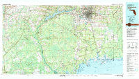
~ Tallahassee FL topo map, 1:100000 scale, 30 X 60 Minute, Historical, 1979, updated 1980
Tallahassee, Florida, USGS topographic map dated 1979.
Includes geographic coordinates (latitude and longitude). This topographic map is suitable for hiking, camping, and exploring, or framing it as a wall map.
Printed on-demand using high resolution imagery, on heavy weight and acid free paper, or alternatively on a variety of synthetic materials.
Topos available on paper, Waterproof, Poly, or Tyvek. Usually shipping rolled, unless combined with other folded maps in one order.
- Product Number: USGS-5621678
- Free digital map download (high-resolution, GeoPDF): Tallahassee, Florida (file size: 29 MB)
- Map Size: please refer to the dimensions of the GeoPDF map above
- Weight (paper map): ca. 55 grams
- Map Type: POD USGS Topographic Map
- Map Series: HTMC
- Map Verison: Historical
- Cell ID: 68436
- Scan ID: 348769
- Imprint Year: 1980
- Woodland Tint: Yes
- Aerial Photo Year: 1976
- Edit Year: 1979
- Datum: NAD27
- Map Projection: Universal Transverse Mercator
- Map published by United States Geological Survey
- Map Language: English
- Scanner Resolution: 600 dpi
- Map Cell Name: Tallahassee
- Grid size: 30 X 60 Minute
- Date on map: 1979
- Map Scale: 1:100000
- Geographical region: Florida, United States
Neighboring Maps:
All neighboring USGS topo maps are available for sale online at a variety of scales.
Spatial coverage:
Topo map Tallahassee, Florida, covers the geographical area associated the following places:
- Jackson Bluff - Sopchoppy - Capitola - Lowry - Helen - Cody - Bristol - Gardner - Liberty - Saint Marks - Fawn Ford - Corey - Smith Creek - Ashmore - Tallahassee - Fort Braden - Lawhons Mill - Sanborn - Lochiocha (historical) - Hilliardville - Topocapa (historical) - Twin Pole - Fanlew - Welika (historical) - Morgan Place - Cohowfoochee (historical) - Lakeside - Lloyd - Woodville - Curtis Mill - Ochisi (historical) - Plum Orchard - Medart - Buckhorn - McCaln - Saint Peter - Newport - Ward - Telogia - Lake View Point - Bethel - Lutterloh - White Springs - Midway - Crawfordville - Henrietta - Skipper - Ivan - Jensen Place - Wethocouchy (historical) - Central City - Andrew - Spring Creek - Wasupa (historical) - Port Leon - Kern - Wakulla - Sumatra - Tully - Limestone - Wakulla Beach - Clio - Lafayette - Four Points - Oak Park - Macon - Conners Ford - Arran - Shell Island - Hosford - Ebenezer - Perkins - Wakulla Springs - Panacea Park - Wakulla Gardens - Bon Ami - Zion Hill - Ochlockonee - Belair - Panacea - Wetumpka - Bloxham - Shadeville - Tama (historical) - San Marcos (historical) - Hyde Park - Mount Pleasant - Vereen - Vilas - Spring Hill - Wilma - Norfleet - Holland - Rose - Live Oak Island - Chaires - Woods
- Map Area ID: AREA30.530-85-84
- Northwest corner Lat/Long code: USGSNW30.5-85
- Northeast corner Lat/Long code: USGSNE30.5-84
- Southwest corner Lat/Long code: USGSSW30-85
- Southeast corner Lat/Long code: USGSSE30-84
- Northern map edge Latitude: 30.5
- Southern map edge Latitude: 30
- Western map edge Longitude: -85
- Eastern map edge Longitude: -84


