
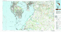
~ St Petersburg FL topo map, 1:100000 scale, 30 X 60 Minute, Historical, 1981, updated 1983
St Petersburg, Florida, USGS topographic map dated 1981.
Includes geographic coordinates (latitude and longitude). This topographic map is suitable for hiking, camping, and exploring, or framing it as a wall map.
Printed on-demand using high resolution imagery, on heavy weight and acid free paper, or alternatively on a variety of synthetic materials.
Topos available on paper, Waterproof, Poly, or Tyvek. Usually shipping rolled, unless combined with other folded maps in one order.
- Product Number: USGS-5621676
- Free digital map download (high-resolution, GeoPDF): St Petersburg, Florida (file size: 27 MB)
- Map Size: please refer to the dimensions of the GeoPDF map above
- Weight (paper map): ca. 55 grams
- Map Type: POD USGS Topographic Map
- Map Series: HTMC
- Map Verison: Historical
- Cell ID: 68288
- Scan ID: 348675
- Imprint Year: 1983
- Woodland Tint: Yes
- Aerial Photo Year: 1979
- Edit Year: 1981
- Datum: NAD27
- Map Projection: Universal Transverse Mercator
- Map published by United States Geological Survey
- Map Language: English
- Scanner Resolution: 600 dpi
- Map Cell Name: Saint Petersburg
- Grid size: 30 X 60 Minute
- Date on map: 1981
- Map Scale: 1:100000
- Geographical region: Florida, United States
Neighboring Maps:
All neighboring USGS topo maps are available for sale online at a variety of scales.
Spatial coverage:
Topo map St Petersburg, Florida, covers the geographical area associated the following places:
- Gemstone Acres - La Carbayera - Pritcher Manor - Sunshine Acres - Nebraska East - Speedway Park - Whitlock - Thomas Oaks - Irma - Tibbettsville - Buckingham - Covina at Bay Park - Taylor Heights - Mackmay - Carter Country - Manhattan Terrace - Providence Lakes - Raulerson Estates South - Piney Point - Happy Homes - Welcome - Sara Anna Estates - Terra Ceia - Sparkman Place - Colson Acres - Nettlow - Williams Crossing - Thea Simmons - Plymouth Court - Winston Manor - Bayshore Estates - Solitude - Byrd Acres - Abbey Grove - High Point Estates - Seffner - Oak Hill Estates - Lukes - Nebraska Heights South - Orangeland - Anna Maria - Norma Park - Arbors at Freedom Plaza - Montana Heights - Habana Court North - Martin - Lullaby Pines - Holloway Plantation - Winchester Woods - Edison - Clifton Gardens - Chamberlins - Winton Park - Pavilion Phase 2 - Villages of Lake Saint Charles - Highland Creek - Brandon Tradewinds - Regency Park North - Kingston Heights - Medley Manor - Gandy Manor Estates - Madrid - Grove Hill Heights - Villa Saint Louis - Murray Acres - Kenlake - Oakford - Tangerine Trails - Krebs - Paradise - Pollard Place - Bel Wil - Sito - Buckhorn Springs Manor - Pooran - Habana Gardens North - West End - West Tampa Heights - Bayview Homes - Michigan Broadway - Friendship Heights - Fairmont Park - Tri Canal Estates - Oakmont Park - South Plant City Farms - Port Royal at Harbour Island - Riverlachen - Armenia Gardens - Keys at Harbour Island - Bindshedler - Mays - Dorchester - Lykes Estates - Marquard Manor - Messick Acres - Moneta - East Bay Farms - Limona - Michigan Heights - Nichols
- Map Area ID: AREA2827.5-83-82
- Northwest corner Lat/Long code: USGSNW28-83
- Northeast corner Lat/Long code: USGSNE28-82
- Southwest corner Lat/Long code: USGSSW27.5-83
- Southeast corner Lat/Long code: USGSSE27.5-82
- Northern map edge Latitude: 28
- Southern map edge Latitude: 27.5
- Western map edge Longitude: -83
- Eastern map edge Longitude: -82


