
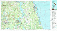
~ Saint Augustine FL topo map, 1:100000 scale, 30 X 60 Minute, Historical, 1981, updated 1982
Saint Augustine, Florida, USGS topographic map dated 1981.
Includes geographic coordinates (latitude and longitude). This topographic map is suitable for hiking, camping, and exploring, or framing it as a wall map.
Printed on-demand using high resolution imagery, on heavy weight and acid free paper, or alternatively on a variety of synthetic materials.
Topos available on paper, Waterproof, Poly, or Tyvek. Usually shipping rolled, unless combined with other folded maps in one order.
- Product Number: USGS-5621670
- Free digital map download (high-resolution, GeoPDF): Saint Augustine, Florida (file size: 29 MB)
- Map Size: please refer to the dimensions of the GeoPDF map above
- Weight (paper map): ca. 55 grams
- Map Type: POD USGS Topographic Map
- Map Series: HTMC
- Map Verison: Historical
- Cell ID: 68276
- Scan ID: 348377
- Imprint Year: 1982
- Woodland Tint: Yes
- Visual Version Number: 1
- Aerial Photo Year: 1977
- Edit Year: 1981
- Datum: NAD27
- Map Projection: Universal Transverse Mercator
- Map published by United States Geological Survey
- Map Language: English
- Scanner Resolution: 600 dpi
- Map Cell Name: Saint Augustine
- Grid size: 30 X 60 Minute
- Date on map: 1981
- Map Scale: 1:100000
- Geographical region: Florida, United States
Neighboring Maps:
All neighboring USGS topo maps are available for sale online at a variety of scales.
Spatial coverage:
Topo map Saint Augustine, Florida, covers the geographical area associated the following places:
- Okawahathako (historical) - Moultrie Junction - Mannville - Palm Coast - Hill Creek Mobile Home Park - Ezra's Landing Mobile Home Park - Lane Landing - Warwick Trailer Park - Sisco - Orange Springs - Saint Augustine Beach - Saint Augustine - Painters Hill - Shell Bluff - Mirror Lake Mobile Home Park - Elkton - San Buenaventura (historical) - Cooper L Hills Estates - Pass Station - Hollister - Dobbs Mobile Home Park - Penney Farms - Spuds - Espanola - Lands End Ranch - Taylor Mobile Home Park - Spanish Trail Mobile Home Park - Crossley - Isabellas Place Mobile Home Park - Lundy - Kingsley - Sutherlands Still - Green Cove Springs - River Villas Manufactured Home Park - Lazy C Mobile Home Park - Meldrim Park - Keuka - Johns Mobile Home Park - Teasdale - Grandin - Saint Augustine Family Park Mobile Home Park - Dupont Center - Fort Peyton - Florahome - Sea Horse Retirees Mobile Home Park - Gopher Ridge - Bon Terra - Myrtle Island - Picolata - Siesta Mobile Home Park - Nashua - Whiteville - Putnam Hall - Vermont Heights - Frog Hollow Court Mobile Home Park - Silver Lake Oaks Mobile Home Village - Araquey - Casa Cola - Bernards Trailer Park - Patersonville - Dimarco Trailer Park - East Palatka - Kingsley Beach - Byrd - West Tocoi - Davis Shores - Hastings - Nombre de Dios (historical) - Possum Bluff - Butler Beach - Brentwood Mobile Home Park - Clay Landing - Coquina Gables - Saint Augustine Shores - Bridgeport - San Nicolas Tolentino (historical) - Grand View Grove - Newt's Trailer Park - Baywood - Rivercrest Trailer Park - Springside Park - Alhambra Mobile Home Community - Orange Mills - Summer Haven - Graceland Mobile Home Park - Flagler by the Sea Mobile Home Park - Edgar - Bostwick - Oak Ridge Park - Pocotalaco (historical) - Coquina Oaks Mobile Home - Buffalo Bluff - Crescent Beach - San Mateo - Vilano Beach - Brewers Landing - Walkill - Ryan's Trailer Park - Roy - Saratoga
- Map Area ID: AREA3029.5-82-81
- Northwest corner Lat/Long code: USGSNW30-82
- Northeast corner Lat/Long code: USGSNE30-81
- Southwest corner Lat/Long code: USGSSW29.5-82
- Southeast corner Lat/Long code: USGSSE29.5-81
- Northern map edge Latitude: 30
- Southern map edge Latitude: 29.5
- Western map edge Longitude: -82
- Eastern map edge Longitude: -81


