
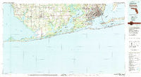
~ Pensacola FL topo map, 1:100000 scale, 30 X 60 Minute, Historical, 1978, updated 1986
Pensacola, Florida, USGS topographic map dated 1978.
Includes geographic coordinates (latitude and longitude). This topographic map is suitable for hiking, camping, and exploring, or framing it as a wall map.
Printed on-demand using high resolution imagery, on heavy weight and acid free paper, or alternatively on a variety of synthetic materials.
Topos available on paper, Waterproof, Poly, or Tyvek. Usually shipping rolled, unless combined with other folded maps in one order.
- Product Number: USGS-5621656
- Free digital map download (high-resolution, GeoPDF): Pensacola, Florida (file size: 27 MB)
- Map Size: please refer to the dimensions of the GeoPDF map above
- Weight (paper map): ca. 55 grams
- Map Type: POD USGS Topographic Map
- Map Series: HTMC
- Map Verison: Historical
- Cell ID: 68134
- Scan ID: 348060
- Imprint Year: 1986
- Woodland Tint: Yes
- Visual Version Number: 1
- Aerial Photo Year: 1976
- Edit Year: 1978
- Datum: NAD27
- Map Projection: Universal Transverse Mercator
- Map published by United States Geological Survey
- Map Language: English
- Scanner Resolution: 600 dpi
- Map Cell Name: Pensacola
- Grid size: 30 X 60 Minute
- Date on map: 1978
- Map Scale: 1:100000
- Geographical region: Florida, United States
Neighboring Maps:
All neighboring USGS topo maps are available for sale online at a variety of scales.
Spatial coverage:
Topo map Pensacola, Florida, covers the geographical area associated the following places:
- Douglas Mobile Home Park - Foley Recreational Vehicle Park - Mallard Point Trailer Court - C'est Lavie Mobile Home Park - Beech Camper and Mobile Home Park - Elijah Shoots Mobile Home Park - Dickerson City - Oriole Beach - River Park - Miflin - Haven Park - Live Oak Mobile Home Park - Warrington - Land Harbor Mobile Home Park - Brewer Circle B Mobile Home Park - Pulliam Village Mobile Home Park - Perdido Bay - Turkey Branch - Johnsons Beach - Gaberonne - Pensacola - Blue Grass Recreational Vehicle Park - Gulf Shores - Dove Run Mobile Home Park - Brownsville - Fort Pickens - East Pensacola Heights - Myrtle Grove - Caswell - Oyster Bay - Brent - Marlow - Josephine - Helens Mobile Home Park and Recreational Vehicle Park - West Pensacola - Perdido Key - Bon Secour - Country Place Mobile Home Park - Dogwood Park Mobile Home Village and Recreational Vehicle Park - Sand Cut - Perdido Beach - Pensacola Beach - Clay City - Moye Hill Park Mobile Home Park - Tristan Village - Bohemia - Chanticleer - Treasure Hill Park - Bayside - Quinavista - Tiger Point - Oleander Court Mobile Home Park - Romar Beach - Bellview - Thompson Mobile Home Park - Sanders Beach - Villa Sabine - Seaglades - Orange Beach - Country Living Mobile Home Park - Sherman Grove - Paradise Beach - Gulf Beach Heights - Point Clear - Country Crossroads Mobile Home Park - Spanish Cove Mobile Home Park - Oak - Cedar Grove - Yupon - Pleasant Grove - Ramsey Beach - Battles Wharf - Foley - Country Living Mobile Home Park - Summerdale - Avondale - Wolf Bay Park Mobile Home Park - Beach Haven - Barnwell - Orchards Mobile Home Park - Whispering Pines Mobile Home Park - Whispering Winds Mobile Home Park - Cerny Heights - Country Village Mobile Home Park - Palmetto Beach - Millview - The Grove Mobile Home Park - Cedar Grove Mobile Home Park - Perdido Heights - Goulding - Magnolia Springs - Cypress Acres Mobile Home Park - Swift - Gulf Breeze - Elberta - Gasque - Key Allegro Villas Mobile Home Park - Lillian - Jacks Trailer Court - Navy Point
- Map Area ID: AREA30.530-88-87
- Northwest corner Lat/Long code: USGSNW30.5-88
- Northeast corner Lat/Long code: USGSNE30.5-87
- Southwest corner Lat/Long code: USGSSW30-88
- Southeast corner Lat/Long code: USGSSE30-87
- Northern map edge Latitude: 30.5
- Southern map edge Latitude: 30
- Western map edge Longitude: -88
- Eastern map edge Longitude: -87


