
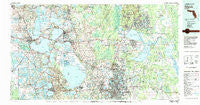
~ Orlando FL topo map, 1:100000 scale, 30 X 60 Minute, Historical, 1979, updated 1980
Orlando, Florida, USGS topographic map dated 1979.
Includes geographic coordinates (latitude and longitude). This topographic map is suitable for hiking, camping, and exploring, or framing it as a wall map.
Printed on-demand using high resolution imagery, on heavy weight and acid free paper, or alternatively on a variety of synthetic materials.
Topos available on paper, Waterproof, Poly, or Tyvek. Usually shipping rolled, unless combined with other folded maps in one order.
- Product Number: USGS-5621648
- Free digital map download (high-resolution, GeoPDF): Orlando, Florida (file size: 31 MB)
- Map Size: please refer to the dimensions of the GeoPDF map above
- Weight (paper map): ca. 55 grams
- Map Type: POD USGS Topographic Map
- Map Series: HTMC
- Map Verison: Historical
- Cell ID: 68099
- Scan ID: 347859
- Imprint Year: 1980
- Woodland Tint: Yes
- Aerial Photo Year: 1977
- Edit Year: 1979
- Datum: NAD27
- Map Projection: Universal Transverse Mercator
- Map published by United States Geological Survey
- Map Language: English
- Scanner Resolution: 600 dpi
- Map Cell Name: Orlando
- Grid size: 30 X 60 Minute
- Date on map: 1979
- Map Scale: 1:100000
- Geographical region: Florida, United States
Neighboring Maps:
All neighboring USGS topo maps are available for sale online at a variety of scales.
Spatial coverage:
Topo map Orlando, Florida, covers the geographical area associated the following places:
- Riverside Acres - Lock Arbor - Minneola - Eldorado - Pine Crest Trailer Park - Hickory Heights Trailer Park - Hilltop Mobile Home Park - Twin Palms Trailer Park - Silver Star Village Mobile Home Park - Country Club Manor - Wekiva - Okahumpka - Eustis - Corley Island Mobile Manor - Christmas - Grand Island - Pine Lakes - Pittman - Tangerine - Valencia Estates Mobile Home Park - Sylvan Lake - Pine Hills - Orange City - Lakeside Mobile Home Court - Bonfire Mobile Home Village - Forest City - Tavares - Osteen - South Sanford Heights - Lordland - Orange Blossom Hills South - Paisley - Silver Beach Heights - Minneola Court Mobile Home Park - Lockwood - Timber Village Mobile Home Park - Crystal Lake Shores - Palm Isles Mobile Home Village - Fairview Shores - Camino Park Mobile Home Park - Spring Hammock Trailer Park - Three Palms Trailer Park - Geneva - Fern Park Mobile Home Park - Slones Ridge - Lakeside Village Mobile Home Park - Fisherman's Paradise Mobile Home Park - Eatonville - Pine Isle Mobile Villa - Bahia Subdivision - Seneca - Cherry Lake - Orange Tree Mobile Home Park - Groves Mobile Home Community - Morgans Mobile Home Park - Whitney - Woodruff Springs - Cow Creek - Lake Griffin Isles Mobile Home Park - Helen Street Mobile Home Park South - Montverde Junction - Lake Helen - Marsh's Trailer Park - Lockhart - Tropicana Mobile Home Park - Orange City Hills - Lakeside Mobile Home Park - Alafaya - Golden Estates Mobile Home Park - Bookertown - Sunlake Estates Mobile Park - Sunland Estates - University Park - Okahumpka (historical) - Pinecrest - Griffwood Mobile Home Park - Yalaha - Merrimac - Confer - Oak Springs Mobile Home Community - Tildenville - Sunset Mobile Home Park - Fern Park - Fullers - Goldenrod - Tiki Village Mobile Home Park - Lady Lake - Trailer City Mobile Home Park - Lake Shore Village Mobile Home Park - Sunnyside - The Retreat at Twin Lakes - Montclair - South Pine Lakes - Rosalind Heights - Molokai Cooperative Mobile Home Park - Riverside - Rock Garden Mobile Home Park - Hawthorne - Lake Mack Park - Sandy Shores Mobile Home Park
- Map Area ID: AREA2928.5-82-81
- Northwest corner Lat/Long code: USGSNW29-82
- Northeast corner Lat/Long code: USGSNE29-81
- Southwest corner Lat/Long code: USGSSW28.5-82
- Southeast corner Lat/Long code: USGSSE28.5-81
- Northern map edge Latitude: 29
- Southern map edge Latitude: 28.5
- Western map edge Longitude: -82
- Eastern map edge Longitude: -81


