
~ Orlando FL topo map, 1:100000 scale, 30 X 60 Minute, Historical, 1979, updated 1992
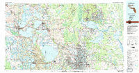
Orlando, Florida, USGS topographic map dated 1979.
Includes geographic coordinates (latitude and longitude). This topographic map is suitable for hiking, camping, and exploring, or framing it as a wall map.
Printed on-demand using high resolution imagery, on heavy weight and acid free paper, or alternatively on a variety of synthetic materials.
Topos available on paper, Waterproof, Poly, or Tyvek. Usually shipping rolled, unless combined with other folded maps in one order.
- Product Number: USGS-5621646
- Free digital map download (high-resolution, GeoPDF): Orlando, Florida (file size: 31 MB)
- Map Size: please refer to the dimensions of the GeoPDF map above
- Weight (paper map): ca. 55 grams
- Map Type: POD USGS Topographic Map
- Map Series: HTMC
- Map Verison: Historical
- Cell ID: 68099
- Scan ID: 347858
- Imprint Year: 1992
- Woodland Tint: Yes
- Visual Version Number: 1
- Aerial Photo Year: 1977
- Edit Year: 1979
- Datum: NAD27
- Map Projection: Universal Transverse Mercator
- Map published by United States Geological Survey
- Map Language: English
- Scanner Resolution: 600 dpi
- Map Cell Name: Orlando
- Grid size: 30 X 60 Minute
- Date on map: 1979
- Map Scale: 1:100000
- Geographical region: Florida, United States
Neighboring Maps:
All neighboring USGS topo maps are available for sale online at a variety of scales.
Spatial coverage:
Topo map Orlando, Florida, covers the geographical area associated the following places:
- Merrimac - Magnolia Mobile Home Park - Mount Homer - Audubon Village Mobile Home Park - Lake Dora Mobile Home Park - University Village Mobile Home Park - Azalea Park - Greenbriar - Piedmont - Waits Junction - Ravenna Park - Longwood - Fern Park - Grand Island Mobile Home Park - Lincoln Heights - Tall Pines Trailer Park - Hillcrest Heights Trailer Park - Mount Plymouth - Dalhousie Acres - Fairways Country Club Mobile Home Park - Highlands Mobile Home Park - Lake Griffin Mobile Home Park - Astor Farms - Wekiva Springs - Orange Blossom - Fort Florida - Lady Lake Mobile Home Park - Pine Lakes - Mid Lakes Resort Mobile Home Park - Emerald Lakes Mobile Village - Sunny Pines Mobile Home Park - Valdez - Palmer Trailer Park - Fairvilla - West Trailer Park Mobile Home Park - Beck Hammock - Lake Villa Estates Mobile Home Park - Bamboo - Riley's Park Mobile Home Park - Valencia Estates Mobile Home Park - The Lakes at Leesburg Mobile Home Park - Orange Bend - College Mobile Park - Wagner - Pinewood Mobile Home Park - Land O' Lakes Mobile Home Park - Zellwood - Clermont - Lane Park - Recreation Plantation Resort - Shady Oaks Mobile Home Park - Saint Johns River Estates - Grand Avenue Trailer Park - Pine Hills - Gabriella - Crystal Point - Skytop - Hideaway Mobile Home Park - Park View - DeBary - Shangri La by the Lake Mobile Home Park - Helen Street Mobile Home Park South - Lakewood Mobile Home Park - Lemon Bluff - Lisbon - Conestoga Mobile Home Park - Cozy Cove Mobile Home Park - South Orange Mobile Home Park - Gotha - Morgans Mobile Home Park - Pine Isle Mobile Villa - Wintons Park Mobile Home Park - Center Hill - Bassville Park - Palm Shadows - Lake Downey Mobile Home Park - Sharp's Mobile Park - Blue Springs Landing - Lake Harris Hide - Away Mobile Home Park - Jones Landing - Lake Helen - Leesburg Landing Mobile Home Park - Orange Blossom Hills South - Lakeside Mobile Home Court - Molokai Cooperative Mobile Home Park - Midway Park - University Park - Lake Mary - Rock Garden Mobile Home Park - Twin Palms Trailer Park - Hawthorne - Rosemont - Enterprise - Bonfire Mobile Home Village - Victoria Gardens Mobile Home Park - Wilsons Trailer Park - Evans Subdivision - Rail's End Mobile Home Park - Christmas - Cypress Creek Mobile Home Park
- Map Area ID: AREA2928.5-82-81
- Northwest corner Lat/Long code: USGSNW29-82
- Northeast corner Lat/Long code: USGSNE29-81
- Southwest corner Lat/Long code: USGSSW28.5-82
- Southeast corner Lat/Long code: USGSSE28.5-81
- Northern map edge Latitude: 29
- Southern map edge Latitude: 28.5
- Western map edge Longitude: -82
- Eastern map edge Longitude: -81


