
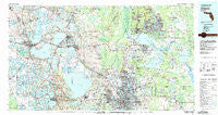
~ Orlando FL topo map, 1:100000 scale, 30 X 60 Minute, Historical, 1979, updated 1992
Orlando, Florida, USGS topographic map dated 1979.
Includes geographic coordinates (latitude and longitude). This topographic map is suitable for hiking, camping, and exploring, or framing it as a wall map.
Printed on-demand using high resolution imagery, on heavy weight and acid free paper, or alternatively on a variety of synthetic materials.
Topos available on paper, Waterproof, Poly, or Tyvek. Usually shipping rolled, unless combined with other folded maps in one order.
- Product Number: USGS-5621644
- Free digital map download (high-resolution, GeoPDF): Orlando, Florida (file size: 31 MB)
- Map Size: please refer to the dimensions of the GeoPDF map above
- Weight (paper map): ca. 55 grams
- Map Type: POD USGS Topographic Map
- Map Series: HTMC
- Map Verison: Historical
- Cell ID: 68099
- Scan ID: 347857
- Imprint Year: 1992
- Woodland Tint: Yes
- Aerial Photo Year: 1977
- Edit Year: 1979
- Datum: NAD27
- Map Projection: Universal Transverse Mercator
- Map published by United States Geological Survey
- Map Language: English
- Scanner Resolution: 600 dpi
- Map Cell Name: Orlando
- Grid size: 30 X 60 Minute
- Date on map: 1979
- Map Scale: 1:100000
- Geographical region: Florida, United States
Neighboring Maps:
All neighboring USGS topo maps are available for sale online at a variety of scales.
Spatial coverage:
Topo map Orlando, Florida, covers the geographical area associated the following places:
- Lake Monroe - Mascotte - Okahumpka - Ocoee - Fairlane Estates - Orange Blossom - Lake Ashby Mobile Home Park - Evansdale - Roan - J and C Mobile Home Park - Sunshine Mobile Home Park - Riviera Mobile Home Park - Harrison Trailer Park - Palmer Trailer Park - Three Lakes Park Mobile Home Park - Lakeside Village Mobile Home Park - Camino Park Mobile Home Park - Cameron City - Palm Ridge Mobile Village - Lake Helen - Orange Bend - Crystal Lake Shores - South Shore Mobile Home Park - Crown Point - Castle Hill - Fairview Mobile Court - Lakewood Mobile Home Park - Clarcona - Country Village Mobile Home Park - Corley Island Mobile Manor - College Mobile Park - Sanford Farms - Weathersfield - South Pine Lakes - Wekiva - Tamarack East Mobile Home Park - Palm Isles Mobile Home Village - Tara Village Mobile Home Park - Sunset Harbor - Whites Landing - Hickory Hollow Estates Mobile Home Park - Montverde - Carriage Cove Mobile Home Park - Pumpkin Center - Silver Beach Heights - Winter Garden - Grand Island Mobile Home Park - Center Hill - Starkes Ferry - Orange Mountain - Leisure Meadows Mobile Home Park - Fort Florida - Orange Tree Mobile Home Park - Wynwood - Markham - Pinecrest - West Trailer Park Mobile Home Park - Zellwood - Orienta Gardens - South Apopka - Reavills Corner - Ferndale - Lake Griffin Harbor Mobile Home Park - Sunnyside - Groveland - Brittany Estates Mobile Home Park - Deltona - Yalaha - Woodruff Springs - Skytop - Lake Apopka - Slavia - Harrell Road Mobile Home Park - Alderene Park - Griffwood Mobile Home Park - Aloma - Confer - Lockhart Mobile Home Park - Lockwood - Slones Ridge - Midway - Deerwood Mobile Home Park - Holiday Acres Mobile Home Park - Forest City - Country Club Manor - Tropical Whisper Mobile Home Park - Molokai Cooperative Mobile Home Park - Hilltop Mobile Home Park - Tall Pines Trailer Park - Fairways Country Club Mobile Home Park - Eatonville - Tranquil Trailer Court - Fairvilla Court Mobile Home Park - Jamestown - Pilaklakha (historical) - Seneca - Rolling Woods Mobile Home Park - Truck Corner - Paola - Tropicana Mobile Home Park
- Map Area ID: AREA2928.5-82-81
- Northwest corner Lat/Long code: USGSNW29-82
- Northeast corner Lat/Long code: USGSNE29-81
- Southwest corner Lat/Long code: USGSSW28.5-82
- Southeast corner Lat/Long code: USGSSE28.5-81
- Northern map edge Latitude: 29
- Southern map edge Latitude: 28.5
- Western map edge Longitude: -82
- Eastern map edge Longitude: -81


