
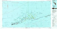
~ Key West FL topo map, 1:100000 scale, 30 X 60 Minute, Historical, 1983, updated 1984
Key West, Florida, USGS topographic map dated 1983.
Includes geographic coordinates (latitude and longitude). This topographic map is suitable for hiking, camping, and exploring, or framing it as a wall map.
Printed on-demand using high resolution imagery, on heavy weight and acid free paper, or alternatively on a variety of synthetic materials.
Topos available on paper, Waterproof, Poly, or Tyvek. Usually shipping rolled, unless combined with other folded maps in one order.
- Product Number: USGS-5621616
- Free digital map download (high-resolution, GeoPDF): Key West, Florida (file size: 30 MB)
- Map Size: please refer to the dimensions of the GeoPDF map above
- Weight (paper map): ca. 55 grams
- Map Type: POD USGS Topographic Map
- Map Series: HTMC
- Map Verison: Historical
- Cell ID: 67760
- Scan ID: 346920
- Imprint Year: 1984
- Woodland Tint: Yes
- Aerial Photo Year: 1980
- Edit Year: 1983
- Datum: NAD27
- Map Projection: Universal Transverse Mercator
- Map published by United States Geological Survey
- Map Language: English
- Scanner Resolution: 600 dpi
- Map Cell Name: Key West
- Grid size: 30 X 60 Minute
- Date on map: 1983
- Map Scale: 1:100000
- Geographical region: Florida, United States
Neighboring Maps:
All neighboring USGS topo maps are available for sale online at a variety of scales.
Spatial coverage:
Topo map Key West, Florida, covers the geographical area associated the following places:
- Roy's Trailer Park - Terra Marine Trailer Park - Pirates Cove - Sunny Isle Trailer Park - Big Coppitt Key - Sunset Harbor Trailer Village - Coconut Grove Mobile Home Park - Seaside Resort Mobile Home Park - Stock Island - Marx Mobile Home Park - Overseas Trailer Park - Cudjoe Key - Waters Edge Colony Mobile Home Park - Tropic Palms Mobile Home Park - Marathon - Howards Haven Mobile Home Park - Bay Point - Sugarloaf Shores - Gulf View Trailer Haven - Marathon Shores - Key Colony Beach - Woodsons Trailer Park - Perky - Liz's Trailer Park - Lucky's Landing Mobile Home Park - Trailerama Mobile Home Park - Big Pine - Leo's Trailer Park - Big Pine Key - El Chico - Galway Bay Mobile Home Park - Stadium Mobile Home Park - Deans Trailer Park - Summerland Key - Key West - Palms Subdivision Trailer Park
- Map Area ID: AREA2524.5-82-81
- Northwest corner Lat/Long code: USGSNW25-82
- Northeast corner Lat/Long code: USGSNE25-81
- Southwest corner Lat/Long code: USGSSW24.5-82
- Southeast corner Lat/Long code: USGSSE24.5-81
- Northern map edge Latitude: 25
- Southern map edge Latitude: 24.5
- Western map edge Longitude: -82
- Eastern map edge Longitude: -81


