
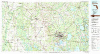
~ Gainesville FL topo map, 1:100000 scale, 30 X 60 Minute, Historical, 1981, updated 1982
Gainesville, Florida, USGS topographic map dated 1981.
Includes geographic coordinates (latitude and longitude). This topographic map is suitable for hiking, camping, and exploring, or framing it as a wall map.
Printed on-demand using high resolution imagery, on heavy weight and acid free paper, or alternatively on a variety of synthetic materials.
Topos available on paper, Waterproof, Poly, or Tyvek. Usually shipping rolled, unless combined with other folded maps in one order.
- Product Number: USGS-5621600
- Free digital map download (high-resolution, GeoPDF): Gainesville, Florida (file size: 26 MB)
- Map Size: please refer to the dimensions of the GeoPDF map above
- Weight (paper map): ca. 55 grams
- Map Type: POD USGS Topographic Map
- Map Series: HTMC
- Map Verison: Historical
- Cell ID: 67555
- Scan ID: 346370
- Imprint Year: 1982
- Woodland Tint: Yes
- Visual Version Number: 1
- Aerial Photo Year: 1977
- Edit Year: 1981
- Datum: NAD27
- Map Projection: Universal Transverse Mercator
- Map published by United States Geological Survey
- Map Language: English
- Scanner Resolution: 600 dpi
- Map Cell Name: Gainesville
- Grid size: 30 X 60 Minute
- Date on map: 1981
- Map Scale: 1:100000
- Geographical region: Florida, United States
Neighboring Maps:
All neighboring USGS topo maps are available for sale online at a variety of scales.
Spatial coverage:
Topo map Gainesville, Florida, covers the geographical area associated the following places:
- Shannon Wood - Hainesworth - Clinch - West Park - Dukes - Lake Geneva - Melrose - Hillcrest Mobile Home Park - Paradise - Louise - Arredondo Estates - Alamar Gardens Mobile Home Park - Thames - Micanopy - Daysville - Wanamake - Grady - Suburban Heights - Rex - Sampson - Wilcox - Burnetts Lake - Spring Hill - Kreftwood Estates - Robinswood - Manatee Road - Hatchbend - Micanopy Junction - Fort White - Hampton Beach - San Francisco Potano (historical) - Fairbanks - Grove Park - Green Grove - Tyler - Whispering Pines Commmunity Mobile Home Park - Bonners Mobile Home Park - Northwood - Woftoka (historical) - Bell - Browns Still - Bland - Wade - Gainesville - Robinson Heights - Craggs - Brittany Estates Mobile Home Park - Hildreth - Windsor - Buckingham West - Durant Estates - Monteocha - Newnans Lake Homesites - Idylwild - Waldo - Riceland - Earleton - Old Town - Park of the Palms - Starke - Beckhamtown - Varsity Mobile Home Villa - Wannee - Oak Park Village Mobile Home Park - Brooker - Alachua II (historical) - Trenton - Pine Hill Estates - Keystone Heights - Fletcher - Copeland Settlement - Kincaid Hills - Brown - Pleasant Grove - Waters Lake - Hawthorne - Mutual - Johnnys Mobile Home Park - Phifer - Shenks - Lake Geneva Mobile Home Park - Williford - Clayno - Sandy Point - Beville Heights - Tacoma - Malore Gardens - Half Moon - Wimberly Estates - South Idylwild - Mikesville - Wilcox Junction - Campville - River Run Campground - Cadillac - Arredondo Farms Mobile Home Park - Los Trancos Woods - Jim Rod Mobile Home Park - Hollingsworth Bluff - Clayton Estates Mobile Home Park
- Map Area ID: AREA3029.5-83-82
- Northwest corner Lat/Long code: USGSNW30-83
- Northeast corner Lat/Long code: USGSNE30-82
- Southwest corner Lat/Long code: USGSSW29.5-83
- Southeast corner Lat/Long code: USGSSE29.5-82
- Northern map edge Latitude: 30
- Southern map edge Latitude: 29.5
- Western map edge Longitude: -83
- Eastern map edge Longitude: -82


