
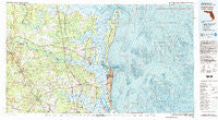
~ Fernandina Beach FL topo map, 1:100000 scale, 30 X 60 Minute, Historical, 1981, updated 1993
Fernandina Beach, Florida, USGS topographic map dated 1981.
Includes geographic coordinates (latitude and longitude). This topographic map is suitable for hiking, camping, and exploring, or framing it as a wall map.
Printed on-demand using high resolution imagery, on heavy weight and acid free paper, or alternatively on a variety of synthetic materials.
Topos available on paper, Waterproof, Poly, or Tyvek. Usually shipping rolled, unless combined with other folded maps in one order.
- Product Number: USGS-5621580
- Free digital map download (high-resolution, GeoPDF): Fernandina Beach, Florida (file size: 35 MB)
- Map Size: please refer to the dimensions of the GeoPDF map above
- Weight (paper map): ca. 55 grams
- Map Type: POD USGS Topographic Map
- Map Series: HTMC
- Map Verison: Historical
- Cell ID: 72158
- Scan ID: 346142
- Imprint Year: 1993
- Woodland Tint: Yes
- Visual Version Number: 2
- Aerial Photo Year: 1977
- Edit Year: 1981
- Datum: NAD27
- Map Projection: Universal Transverse Mercator
- Map published by United States Geological Survey
- Map Language: English
- Scanner Resolution: 600 dpi
- Map Cell Name: Fernandina Beach
- Grid size: 30 X 60 Minute
- Date on map: 1981
- Map Scale: 1:100000
- Geographical region: Florida, United States
Neighboring Maps:
All neighboring USGS topo maps are available for sale online at a variety of scales.
Spatial coverage:
Topo map Fernandina Beach, Florida, covers the geographical area associated the following places:
- Mays Bluff - Gross Still (historical) - American Beach - Fernandina Beach - North River Oaks - Evergreen - Joels Landing - Nassau Acres Mobile Home Park - Southern Pines Mobile Home Park - Sadlers Cove - Woodhaven - Nassau Village - Bullhead Bluff - Rains Landing - Fawnwood - Woodstock (historical) - Pecan Park - Ruby's Mobile Home Park - Boulogne - Colesburg - Hopewell - Clarks Bluff - Flea Hill - Harbor Pines - Harrietts Bluff Village - Palmetto Pines Mobile Home Park - Deer Run - Hazlehurst - Sadlers Landing - Mission Trace - Riverview - London Hill - Billyville - Halifax - Foxwood - Hilliard - Glenwood - Camp Pinkney (historical) - Old Fernandina - Saint Marys - Layton - Plantation Oaks - Plantation Point - Silco - Camden Point Mobile Home Park - Franklintown - Tompkins - Village Oaks Mobile Home Park - High Point - Cypress Lake Estates - Amelia City - Crandall - Kent - Colerain - Kinlaw - Mariners Landing - Terra Haute - Becker - Andrews - Chester - Refuge (historical) - Crooked River Plantation - Marianna (historical) - Forestview - Stafford - Highland Oaks - Old Amelia Mobile Home Park - Deals Landing - Hedges - Lands End - Sugar Mill Plantation - Forest Ridge - Scotchville - Shady Rest - Italia - Wolfbay - North River Marshes - Martin Glen - The Meadows - Runnymeade - Ratliff - River Cove - Oakwood Homes Mobile Home Park - May Creek - Callahan - River Oaks - Amelia Island Mobile Home Park - Sandpiper Mobile Home Park - Elliotts Plantation - Creekwood - Black Hammock - Grover View - Dyal - Bristol Hammock - Centerville (historical) - Woodland Mobile Home Estates - Prescott (historical) - Greentree - Ceylon - Seals
- Map Area ID: AREA3130.5-82-81
- Northwest corner Lat/Long code: USGSNW31-82
- Northeast corner Lat/Long code: USGSNE31-81
- Southwest corner Lat/Long code: USGSSW30.5-82
- Southeast corner Lat/Long code: USGSSE30.5-81
- Northern map edge Latitude: 31
- Southern map edge Latitude: 30.5
- Western map edge Longitude: -82
- Eastern map edge Longitude: -81


