
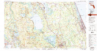
~ Daytona Beach FL topo map, 1:100000 scale, 30 X 60 Minute, Historical, 1978, updated 1980
Daytona Beach, Florida, USGS topographic map dated 1978.
Includes geographic coordinates (latitude and longitude). This topographic map is suitable for hiking, camping, and exploring, or framing it as a wall map.
Printed on-demand using high resolution imagery, on heavy weight and acid free paper, or alternatively on a variety of synthetic materials.
Topos available on paper, Waterproof, Poly, or Tyvek. Usually shipping rolled, unless combined with other folded maps in one order.
- Product Number: USGS-5621574
- Free digital map download (high-resolution, GeoPDF): Daytona Beach, Florida (file size: 28 MB)
- Map Size: please refer to the dimensions of the GeoPDF map above
- Weight (paper map): ca. 55 grams
- Map Type: POD USGS Topographic Map
- Map Series: HTMC
- Map Verison: Historical
- Cell ID: 67388
- Scan ID: 345754
- Imprint Year: 1980
- Woodland Tint: Yes
- Visual Version Number: 1
- Aerial Photo Year: 1977
- Edit Year: 1978
- Datum: NAD27
- Map Projection: Universal Transverse Mercator
- Map published by United States Geological Survey
- Map Language: English
- Scanner Resolution: 600 dpi
- Map Cell Name: Daytona Beach
- Grid size: 30 X 60 Minute
- Date on map: 1978
- Map Scale: 1:100000
- Geographical region: Florida, United States
Neighboring Maps:
All neighboring USGS topo maps are available for sale online at a variety of scales.
Spatial coverage:
Topo map Daytona Beach, Florida, covers the geographical area associated the following places:
- East Lake Weir - Candlelight Manor Mobile Home Estates - Grand Oaks Mobile Home Park - Lynne - Shangri La Mobile Villa - Bunnell - Yellow Bluff - Lake Dorr Mobile Home Park - Urbans Mobile Home Park - Crescent City - DeLand Highlands - Seabreeze - Lake in the Forest Estates Mobile Home Park - Alexander Springs - Fort McCoy - Nubys Corner - Codys Corner - Bear Creek Mobile Home Park - Smith Lake Shores Village Mobile Home Park - Forest Corners - Crescent City Station - North DeLand - Ra Mar Mobile Home Park - Hammond - Hanks Hideaway Mobile Home Park - Granada Mobile Home Park - Carriage Cove Mobile Home Park - Volusia - Deadman Landing - Point Pleasant - Huntington - Crane Lakes Mobile Home Park - Holly Forest Estates Mobile Home Park - Sunny Sands Resort Mobile Home Park - Elmwood Mobile Home Park - Flagler Beach - New Run - River Forest - Bakerstown - Forest Lakes Park - Cozy Circle Trailer Park - Mosquito Grove - Forest Hills - Norwalk - Tall Timber Mobile Home Park - Hidden Valley Park Mobile Home Park - Phoenix Estates Mobile Home Park - Iowa Trailer Park - A Better Place Phase III Mobile Home Park - Palm Mobile Home Park - Welaka - Lake Weir - Lake Como - Cedar Creek - Salt Springs Village Mobile Home Park - Daytona Twin Oaks Mobile Home Park - Lake Waldena Resort Mobile Home Park - Blake - Camelot Mobile Home Park - Arroyo Mobile Home Park - Bass Capital Mobile Home Park - Astor Park - Colony in the Wood Mobile Home Park - Andalusia - Bull Creek Mobile Home Park - Royal Oak Trailer Park - Lingering Lane Mobile Home Park - Flagler Beach Trailer Park - Pierson - Daytona Park Estates - Grahamsville - Lake Kathryn Heights - June Terrace Mobile Home Park - Bay Lake - Shady Village Mobile Home Park - Applegate Estates Mobile Home Park - National Gardens - Shirley Place - Lighthouse Pointe at Daytona Beach Mobile Home Park - Perrywood Villa Mobile Home Community - Lake Kathryn - DeLand - Eureka - Glenwood - Lamplighter Mobile Home Community - Dupont - Big Scrub - Sweetgum Mobile Home Park - Fernwood Mobile Home Park - Camp Ocala - Powells Campground Mobile Home Park - Fullerville - Deland Municipal Trailer Park - Sago Palm Mobile Home Park - Robin Hood Terrace Mobile Home Park - Lakeview Estates Mobile Home Park - Shady Oaks Mobile Home Park - Sha De Land Mobile Home Park - Cypress Lake Estates - Ocklawaha
- Map Area ID: AREA29.529-82-81
- Northwest corner Lat/Long code: USGSNW29.5-82
- Northeast corner Lat/Long code: USGSNE29.5-81
- Southwest corner Lat/Long code: USGSSW29-82
- Southeast corner Lat/Long code: USGSSE29-81
- Northern map edge Latitude: 29.5
- Southern map edge Latitude: 29
- Western map edge Longitude: -82
- Eastern map edge Longitude: -81


