
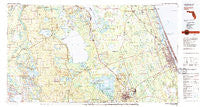
~ Daytona Beach FL topo map, 1:100000 scale, 30 X 60 Minute, Historical, 1978, updated 1980
Daytona Beach, Florida, USGS topographic map dated 1978.
Includes geographic coordinates (latitude and longitude). This topographic map is suitable for hiking, camping, and exploring, or framing it as a wall map.
Printed on-demand using high resolution imagery, on heavy weight and acid free paper, or alternatively on a variety of synthetic materials.
Topos available on paper, Waterproof, Poly, or Tyvek. Usually shipping rolled, unless combined with other folded maps in one order.
- Product Number: USGS-5621572
- Free digital map download (high-resolution, GeoPDF): Daytona Beach, Florida (file size: 26 MB)
- Map Size: please refer to the dimensions of the GeoPDF map above
- Weight (paper map): ca. 55 grams
- Map Type: POD USGS Topographic Map
- Map Series: HTMC
- Map Verison: Historical
- Cell ID: 67388
- Scan ID: 345753
- Imprint Year: 1980
- Woodland Tint: Yes
- Aerial Photo Year: 1977
- Edit Year: 1978
- Datum: NAD27
- Map Projection: Universal Transverse Mercator
- Map published by United States Geological Survey
- Map Language: English
- Scanner Resolution: 600 dpi
- Map Cell Name: Daytona Beach
- Grid size: 30 X 60 Minute
- Date on map: 1978
- Map Scale: 1:100000
- Geographical region: Florida, United States
Neighboring Maps:
All neighboring USGS topo maps are available for sale online at a variety of scales.
Spatial coverage:
Topo map Daytona Beach, Florida, covers the geographical area associated the following places:
- Saint Francis - Nubys Corner - Brookwood Mobile Home Park - Korona - Lake Crescent Mobile Home Park - Grahamsville - Plantation Oaks Mobile Home Park - Lakeview Terrace Mobile Home Park - Connersville - Deland Municipal Trailer Park - Lynne - Bear Creek Mobile Home Park - Codys Corner - Hidden Valley Park Mobile Home Park - Georgetown - River Forest - Hide - a - Way Cove Mobile Home Park - Blairs Jungle Den Mobile Home Park - Carriage Cove Mobile Home Park - Fullerville - Deep Woods Mobile Home Park - Urbans Mobile Home Park - Bull Creek Mobile Home Park - Orangewood Mobile Home Park - Babbitts Mobile Home Park - DeLand Highlands - Huntington - Royal Oak Trailer Park - Town and Country Mobile Home Park - Relay - Shangri La Mobile Villa - Elmwood Mobile Home Park - Lynn - Bass Capital Mobile Home Park - Yellow Bluff - Holly Hill - Forest Hills - Andalusia - Hanks Hideaway Mobile Home Park - Shady Oaks Mobile Home Park - Ashland Mobile Home Park - North DeLand - Dupont - Reed Canal Trailer Park - Cozy Circle Trailer Park - Ellinor Village - Shady Village Mobile Home Park - De Leon Springs - Salt Springs Village Mobile Home Park - Crows Bluff - On the Lake Park Mobile Home Park - Ra Mar Mobile Home Park - Iowa Trailer Park - Double D Mobile Ranch - Denver - Bruceville - A Better Place Phase III Mobile Home Park - Lamplighter Mobile Home Community - Lake Waldena Resort Mobile Home Park - Flagler Beach - Meadowlea Estates Mobile Home Park - Norwalk - Favoretta - Lake Dorr Mobile Home Park - Eldridge - Welaka - Barberville - Ocklawaha - Pierson - Daytona Twin Oaks Mobile Home Park - Tall Pines Mobile Home Park - Holiday Village Mobile Home Park - New Run - Fernwood Mobile Home Park - Eureka - Sago Palm Mobile Home Park - Colonial Colony North Mobile Home Park - Blake - Forest Lakes Park - Daytona Park Estates - Arroyo Mobile Home Park - East Silver Springs Shore - A Better Place Mobile Home Park - El Ray Trailer Park - Seville - Sunny Sands Resort Mobile Home Park - Hillside Trailer Park - Sha De Land Mobile Home Park - Applegate Estates Mobile Home Park - Ormond Beach - Westwood Mobile Home Park - Lingering Lane Mobile Home Park - Phoenix Estates Mobile Home Park - Samsula - Colonial Colony South Mobile Home Park - Beresford - Manhatten - Grand Oaks Mobile Home Park - Cedar Creek - Emporia
- Map Area ID: AREA29.529-82-81
- Northwest corner Lat/Long code: USGSNW29.5-82
- Northeast corner Lat/Long code: USGSNE29.5-81
- Southwest corner Lat/Long code: USGSSW29-82
- Southeast corner Lat/Long code: USGSSE29-81
- Northern map edge Latitude: 29.5
- Southern map edge Latitude: 29
- Western map edge Longitude: -82
- Eastern map edge Longitude: -81


