
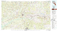
~ Crestview FL topo map, 1:100000 scale, 30 X 60 Minute, Historical, 1978, updated 1982
Crestview, Florida, USGS topographic map dated 1978.
Includes geographic coordinates (latitude and longitude). This topographic map is suitable for hiking, camping, and exploring, or framing it as a wall map.
Printed on-demand using high resolution imagery, on heavy weight and acid free paper, or alternatively on a variety of synthetic materials.
Topos available on paper, Waterproof, Poly, or Tyvek. Usually shipping rolled, unless combined with other folded maps in one order.
- Product Number: USGS-5621566
- Free digital map download (high-resolution, GeoPDF): Crestview, Florida (file size: 26 MB)
- Map Size: please refer to the dimensions of the GeoPDF map above
- Weight (paper map): ca. 55 grams
- Map Type: POD USGS Topographic Map
- Map Series: HTMC
- Map Verison: Historical
- Cell ID: 67359
- Scan ID: 345664
- Imprint Year: 1982
- Woodland Tint: Yes
- Visual Version Number: 1
- Aerial Photo Year: 1976
- Edit Year: 1978
- Datum: NAD27
- Map Projection: Universal Transverse Mercator
- Map published by United States Geological Survey
- Map Language: English
- Scanner Resolution: 600 dpi
- Map Cell Name: Crestview
- Grid size: 30 X 60 Minute
- Date on map: 1978
- Map Scale: 1:100000
- Geographical region: Florida, United States
Neighboring Maps:
All neighboring USGS topo maps are available for sale online at a variety of scales.
Spatial coverage:
Topo map Crestview, Florida, covers the geographical area associated the following places:
- Glendale - Belandville - Cluster Springs - Flowersville - Harold - Kellys Mill - Nubbin Ridge - Auburn - Milligan - Walcan - Ward Basin - Caney Creek - Floridale - Cannon Town - Pleasant Grove - Ealum - Paxton - Leonia - Laurel Hill - Union - Clear Springs - Lakewood - Beaver Creek - Sellersville - Broxson - Roeville - McLellan - Alpine Heights - Sand Hill - Niceville - Clear Springs - Galliver - Dixon - Okaloo - Deerland - New Harmony - De Funiak Springs - Gaskin - Svea - Liberty - Killingsworth Crossroads - Good Hope - Baker - Pond Creek - Peaden - Santa Maria - Silver Springs - Garden City - Blackman - Pine Bluff - Pleasant Ridge - Steele Church - Oak Grove - Munson - Campton - Piney Grove - Spring Hill - New Home - Darlington - Rock Creek - Gordon - Holt - Mossy Head - Crestview - Argyle - Dorcas - Center Ridge - Forest Highlands - Parkerville - Koerber - Escambia Farms - Portland - Eucheeanna - Indian Ford - Pleasant Grove - Valparaiso - Sconiers Mill - Cosson Mill - Simmons Crossing - Rock Hill
- Map Area ID: AREA3130.5-87-86
- Northwest corner Lat/Long code: USGSNW31-87
- Northeast corner Lat/Long code: USGSNE31-86
- Southwest corner Lat/Long code: USGSSW30.5-87
- Southeast corner Lat/Long code: USGSSE30.5-86
- Northern map edge Latitude: 31
- Southern map edge Latitude: 30.5
- Western map edge Longitude: -87
- Eastern map edge Longitude: -86


