
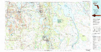
~ Bartow FL topo map, 1:100000 scale, 30 X 60 Minute, Historical, 1978, updated 1980
Bartow, Florida, USGS topographic map dated 1978.
Includes geographic coordinates (latitude and longitude). This topographic map is suitable for hiking, camping, and exploring, or framing it as a wall map.
Printed on-demand using high resolution imagery, on heavy weight and acid free paper, or alternatively on a variety of synthetic materials.
Topos available on paper, Waterproof, Poly, or Tyvek. Usually shipping rolled, unless combined with other folded maps in one order.
- Product Number: USGS-5621548
- Free digital map download (high-resolution, GeoPDF): Bartow, Florida (file size: 24 MB)
- Map Size: please refer to the dimensions of the GeoPDF map above
- Weight (paper map): ca. 55 grams
- Map Type: POD USGS Topographic Map
- Map Series: HTMC
- Map Verison: Historical
- Cell ID: 67099
- Scan ID: 345071
- Imprint Year: 1980
- Woodland Tint: Yes
- Visual Version Number: 1
- Aerial Photo Year: 1973
- Edit Year: 1978
- Datum: NAD27
- Map Projection: Universal Transverse Mercator
- Map published by United States Geological Survey
- Map Language: English
- Scanner Resolution: 600 dpi
- Map Cell Name: Bartow
- Grid size: 30 X 60 Minute
- Date on map: 1978
- Map Scale: 1:100000
- Geographical region: Florida, United States
Neighboring Maps:
All neighboring USGS topo maps are available for sale online at a variety of scales.
Spatial coverage:
Topo map Bartow, Florida, covers the geographical area associated the following places:
- Mid Lakes Mobile Home Park - Bonnie - Fort Green Springs - Cox Corner - Roux Quarters - B and W Mobile Home Park - Wahneta - Lake Shipp Heights - Bereah - Hagners Trailer Park - Grape Hammock Mobile Home Park - Harrys Harbor Mobile Home Park - Harrells Mobile Home Park - Indian Lake Estates - Fedhaven - Green Bay - Lake Garfield - The Harbor Mobile Home Park - Eagle Ridge Mobile Home Park - Winterset Shores Estates Mobile Home Park - Southland Mobile Home Park - Bradley Junction - Eloise - Vandolah - Alcoma - Walden Shores Mobile Home Park - Paradise Lakes Mobile Home Park - Bonnie Brae Mobile Home Estates - Maxcy Quarters - Orange Manor Mobile Home Park West - Lyle Corner - Villa del Sol Mobile Home Park - Homeland - Sebring Shores - Fuller Heights - Agricola - Pedaler's Pond Mobile Home Park - Ridge Trailer Park - Sebring Village Mobile Home Park - Lake Millsite Estates Mobile Home Park - Southern Pines Mobile Home Resort - Whidden Mobile Home Park Number 2 - Bobs Landing Mobile Home Park - Mountain Lake Station - Hammock Lake Mobile Estates - Brewster (historical) - Marina Cove Mobile Home Park - Lake Glenada Mobile Home Park - Babson Park - Fort Meade Mobile Home Park - Lakemont - Enchanted Grove Mobile Home Park - Lake of the Hills - Wauchula Hills - Winter Haven Mobile Home Park - Rosemont Mobile Home Park - Gordonville - Chelette Manor Mobile Home Park - Reflections on Silver Lake Mobile Home Park - Lakeside Gardens Mobile Home Park - Carroll Mobile Home Park - Dinner Lake Haven Mobile Home - Laurel Mobile Home Park - Tanglewood Mobile Home Park - Baird - Oponys Town (historical) - Wolfolk - Pittsburg - Lake Wales - Orange Manor Mobile Home Park East - College Park Mobile Home Park - Hillcrest Heights - J B's Mobile Home Park - Sunny Ridge Mobile Home Park - Cacema Town (historical) - Oak Terrace - Garden Mobile Village - Fort Green - Coker - Lake Clinch Manor Mobile Home Park - Cypress Knee Cove Mobile Home Park - Hickory Lake Estates Mobile Home Park - Pierce - Pine Dale - Bowling Green - Orange Blossom Fellowship Community Mobile Home Park - Lake Wales Mobile Home Park - Dalley Town Park Mobile Home Park - Eagle Lake - West Frostproof - Ridgewood - Sebring Resort Mobile Home Park - Waverly - Tiger Bay - Cypress Acres Mobile Home Park - Pleasant View Mobile Home Park - Green Acres Mobile Home Park - Highland City - Hammondell Mobile Home Park - Lake Pointe Village Mobile Home Park
- Map Area ID: AREA2827.5-82-81
- Northwest corner Lat/Long code: USGSNW28-82
- Northeast corner Lat/Long code: USGSNE28-81
- Southwest corner Lat/Long code: USGSSW27.5-82
- Southeast corner Lat/Long code: USGSSE27.5-81
- Northern map edge Latitude: 28
- Southern map edge Latitude: 27.5
- Western map edge Longitude: -82
- Eastern map edge Longitude: -81


