
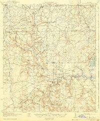
~ Middleburg FL topo map, 1:62500 scale, 15 X 15 Minute, Historical, 1918, updated 1943
Middleburg, Florida, USGS topographic map dated 1918.
Includes geographic coordinates (latitude and longitude). This topographic map is suitable for hiking, camping, and exploring, or framing it as a wall map.
Printed on-demand using high resolution imagery, on heavy weight and acid free paper, or alternatively on a variety of synthetic materials.
Topos available on paper, Waterproof, Poly, or Tyvek. Usually shipping rolled, unless combined with other folded maps in one order.
- Product Number: USGS-5621354
- Free digital map download (high-resolution, GeoPDF): Middleburg, Florida (file size: 7 MB)
- Map Size: please refer to the dimensions of the GeoPDF map above
- Weight (paper map): ca. 55 grams
- Map Type: POD USGS Topographic Map
- Map Series: HTMC
- Map Verison: Historical
- Cell ID: 57591
- Scan ID: 347492
- Imprint Year: 1943
- Edit Year: 1941
- Survey Year: 1917
- Datum: Unstated
- Map Projection: Polyconic
- Map published by United States Geological Survey
- Map published by United States Army Corps of Engineers
- Map published by United States Department of War
- Map Language: English
- Scanner Resolution: 600 dpi
- Map Cell Name: Middleburg
- Grid size: 15 X 15 Minute
- Date on map: 1918
- Map Scale: 1:62500
- Geographical region: Florida, United States
Neighboring Maps:
All neighboring USGS topo maps are available for sale online at a variety of scales.
Spatial coverage:
Topo map Middleburg, Florida, covers the geographical area associated the following places:
- Hewitt Street Mobile Home Park - Westport Mobile Home Park - Country Roads Mobile Home Community - Jamestown Estates Mobile Home Park - Park Ridge Mobile Home Park - Carr Mobile Home Village - Town and Country Mobile Home Park - Black Creek (historical) - Solite (historical) - Rattlesnake Bend - Crystal Oaks Mobile Home Park - Rideout - Oak Hill - Ridgewood - Shawn Lane Mobile Home Park - Sunny Acres Mobile Home Park - Oak Hill Park - Westwood - Arrow Lane Mobile Home Park - Whispering Pines Trailer Park - Asbury Lake - Pine Breeze Mobile Home Park - Oak Ridge Mobile Home Village - Lakeside - North Meadowbrook Terrace - Peoria Siding - Fiftone - Doctors Inlet - Enchanted Park - Middleburg - Connie Jean Mobile Home Park - Argyle Forest - Circle Eleven Mobile Home Park
- Map Area ID: AREA30.2530-82-81.75
- Northwest corner Lat/Long code: USGSNW30.25-82
- Northeast corner Lat/Long code: USGSNE30.25-81.75
- Southwest corner Lat/Long code: USGSSW30-82
- Southeast corner Lat/Long code: USGSSE30-81.75
- Northern map edge Latitude: 30.25
- Southern map edge Latitude: 30
- Western map edge Longitude: -82
- Eastern map edge Longitude: -81.75


