
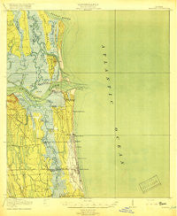
~ Mayport FL topo map, 1:62500 scale, 15 X 15 Minute, Historical, 1918
Mayport, Florida, USGS topographic map dated 1918.
Includes geographic coordinates (latitude and longitude). This topographic map is suitable for hiking, camping, and exploring, or framing it as a wall map.
Printed on-demand using high resolution imagery, on heavy weight and acid free paper, or alternatively on a variety of synthetic materials.
Topos available on paper, Waterproof, Poly, or Tyvek. Usually shipping rolled, unless combined with other folded maps in one order.
- Product Number: USGS-5621344
- Free digital map download (high-resolution, GeoPDF): Mayport, Florida (file size: 7 MB)
- Map Size: please refer to the dimensions of the GeoPDF map above
- Weight (paper map): ca. 55 grams
- Map Type: POD USGS Topographic Map
- Map Series: HTMC
- Map Verison: Historical
- Cell ID: 57296
- Scan ID: 347406
- Woodland Tint: Yes
- Survey Year: 1917
- Datum: Unstated
- Map Projection: Unstated
- Map published by United States Geological Survey
- Map published by United States Army Corps of Engineers
- Map published by United States Department of War
- Map Language: English
- Scanner Resolution: 600 dpi
- Map Cell Name: Mayport
- Grid size: 15 X 15 Minute
- Date on map: 1918
- Map Scale: 1:62500
- Geographical region: Florida, United States
Neighboring Maps:
All neighboring USGS topo maps are available for sale online at a variety of scales.
Spatial coverage:
Topo map Mayport, Florida, covers the geographical area associated the following places:
- Buccaneer Mobile Home Park - Oak Landing - Atlantic Village Mobile Home Park - Pablo Keys - Holiday Harbor - San Pablo - Atlantic Beach - Isle of Palms South - Portside Mobile Home Park - Neptune Beach - Cedar Point - Fulton - East Mayport (historical) - Oak Harbor - Oaks of Atlantic Beach Mobile Home Park - Van Zile Mobile Home Park - Isle of Palms - Greenfield - Sans Pareil - Golfair Trailer Park - Fort George Island - Manhattan Beach - Wonderwood - Mayport Mobile Home Park - Donner - Jacksonville Beach - East Mayport - Admiral's Walk Mobile Home Estates - Mayport
- Map Area ID: AREA30.530.25-81.5-81.25
- Northwest corner Lat/Long code: USGSNW30.5-81.5
- Northeast corner Lat/Long code: USGSNE30.5-81.25
- Southwest corner Lat/Long code: USGSSW30.25-81.5
- Southeast corner Lat/Long code: USGSSE30.25-81.25
- Northern map edge Latitude: 30.5
- Southern map edge Latitude: 30.25
- Western map edge Longitude: -81.5
- Eastern map edge Longitude: -81.25


