
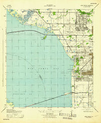
~ Gandy Bridge FL topo map, 1:31680 scale, 7.5 X 7.5 Minute, Historical, 1943
Gandy Bridge, Florida, USGS topographic map dated 1943.
Includes geographic coordinates (latitude and longitude). This topographic map is suitable for hiking, camping, and exploring, or framing it as a wall map.
Printed on-demand using high resolution imagery, on heavy weight and acid free paper, or alternatively on a variety of synthetic materials.
Topos available on paper, Waterproof, Poly, or Tyvek. Usually shipping rolled, unless combined with other folded maps in one order.
- Product Number: USGS-5620822
- Free digital map download (high-resolution, GeoPDF): Gandy Bridge, Florida (file size: 5 MB)
- Map Size: please refer to the dimensions of the GeoPDF map above
- Weight (paper map): ca. 55 grams
- Map Type: POD USGS Topographic Map
- Map Series: HTMC
- Map Verison: Historical
- Cell ID: 16751
- Scan ID: 346396
- Woodland Tint: Yes
- Datum: NAD27
- Map Projection: Polyconic
- Map published by United States Geological Survey
- Map Language: English
- Scanner Resolution: 600 dpi
- Map Cell Name: Gandy Bridge
- Grid size: 7.5 X 7.5 Minute
- Date on map: 1943
- Map Scale: 1:31680
- Geographical region: Florida, United States
Neighboring Maps:
All neighboring USGS topo maps are available for sale online at a variety of scales.
Spatial coverage:
Topo map Gandy Bridge, Florida, covers the geographical area associated the following places:
- Parkdale - Virginia Terrace - Entrada - Westwego - East View - Clarice Place - Morningside - Tampa Villas South - Sweetwater Estates - Drew Park - Mariner Estates - Villa Sonoma at International Plaza - Golf View Estates - Bayside West - Henderson Place - Golden Estates - Overlook - Seldomridge - Golfwood Estates - Milgwen - Beans - Raines - Cole - Bon Air West - Temple Square - Gandy Boulevard Park - Ronnie Place - Morrison Court - Regency Cove - Andrea - Benjamins Farms - Crowder - White Estates - Emerson - Saint Clear Place - Sunset Park - Bayside East - Beach Park - West View - Ad Mer - Gandy Manor - Madigan Park - Manhattan - Weiland - The Reserve of Old Tampa Bay - Watts - Sheridan - Tampania - Krentel Park - Griflow Park - Forest Heights - MacKenzie - Kingston Court Villas - El Prado Gardens - Interbay - San Orludo - Eleanor Villas - Sunset Park Isles - Azeele Heights - Bell Park - Bel Mar Shores - Van Diver Place - Triangle Heights - Westshore Estates South - Palermo - Midwest - Gray Terrace - Picadilly - Horizon Place - Omar - Spencer Place - Guernsey Estates - Lincoln Gardens - Woodward - Southland - Keystone Homes - Alta Vista Tracts - Park West - Rico Diaz - Carol Shores - Leila Avenue Villas - Chandler - Treasure Park - Anita - West Virginia Place - Gandy Manor Estates - Bayside Village - Keats - Bonnie Brae - Roberts - Sunset Beach - School View Estates - West Shore Manor - Louis Place - Pine Grove - Anadell - West Shore Crest - Pershing Park - Gardenia - Stewart
- Map Area ID: AREA2827.875-82.625-82.5
- Northwest corner Lat/Long code: USGSNW28-82.625
- Northeast corner Lat/Long code: USGSNE28-82.5
- Southwest corner Lat/Long code: USGSSW27.875-82.625
- Southeast corner Lat/Long code: USGSSE27.875-82.5
- Northern map edge Latitude: 28
- Southern map edge Latitude: 27.875
- Western map edge Longitude: -82.625
- Eastern map edge Longitude: -82.5


