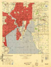
~ Tampa FL topo map, 1:25000 scale, 7.5 X 7.5 Minute, Historical, 1947
Tampa, Florida, USGS topographic map dated 1947.
Includes geographic coordinates (latitude and longitude). This topographic map is suitable for hiking, camping, and exploring, or framing it as a wall map.
Printed on-demand using high resolution imagery, on heavy weight and acid free paper, or alternatively on a variety of synthetic materials.
Topos available on paper, Waterproof, Poly, or Tyvek. Usually shipping rolled, unless combined with other folded maps in one order.
- Product Number: USGS-5620674
- Free digital map download (high-resolution, GeoPDF): Tampa, Florida (file size: 17 MB)
- Map Size: please refer to the dimensions of the GeoPDF map above
- Weight (paper map): ca. 55 grams
- Map Type: POD USGS Topographic Map
- Map Series: HTMC
- Map Verison: Historical
- Cell ID: 44262
- Scan ID: 348786
- Woodland Tint: Yes
- Aerial Photo Year: 1942
- Datum: NAD27
- Map Projection: Transverse Mercator
- Map published by United States Army Corps of Engineers
- Map published by United States Army
- Map Language: English
- Scanner Resolution: 600 dpi
- Map Cell Name: Tampa
- Grid size: 7.5 X 7.5 Minute
- Date on map: 1947
- Map Scale: 1:25000
- Geographical region: Florida, United States
Neighboring Maps:
All neighboring USGS topo maps are available for sale online at a variety of scales.
Spatial coverage:
Topo map Tampa, Florida, covers the geographical area associated the following places:
- Homelands - Sperry - Turleys - Palm River Reserve - Montana Heights - Marie Heights - Uleta - Newnan - Durrance Palm River Estates - Turner - Panama - Mooreland - Chapin Green - Suburb Royal - Courier City - Brookside - Bour Lands - Franklin Place - Mar Cha Long - Orange Wood Park - Mossy Oaks - Rocky Shore - Stylerite Estates - Cones - Swannsylvania - Locicero Columbia Park - Roland Place - Orange Hill Heights West - Shell Point Estates - Tyndell-Maxwell - Los Cien - Larsen Place - Rhoda Lee - Southern Pines - Friendship - Seminole Heights East - Nunez - Collins Armenia Park - Dorothy Park - Montana City - Wests - Baypointe - Rainbow Heights - Vultee - Ownahome - Central Village - West End - Bungalow City - The Willows of Hyde Park - Eugene Terrace - Sunnyside - Erin Place - Holden - Uceta Heights - Georgia Park - Bunchville - Blakes - Packwood - Otis - Francis - Palm - Michigan Heights - Berriman Place - Romany Tan - Murray Heights - Aurora - Broadway - The Hammock - Seabreeze - Oak Heights - Shadowlawn - Highland Pines - Oak Shadows - Capitano - Bungalow Terrace - Gary - Pardeau Shores - Keys at Harbour Island - Goldmine - Westmont Terrace - Tri Canal Estates - Plymouth Court - Hidden Haven - La Carbayera - Ta Wes Co Place - Villa Saint Louis - Rubio Estates - Whittemore - Madison-Cole - Sito - Hyde Park West - Rosemont Villa - Nebraska Park - Vicente Guerra - Baya Vista - Palma Ceia Park - College Heights - Powhatan Heights - Garden Acres - Cortinos
- Map Area ID: AREA2827.875-82.5-82.375
- Northwest corner Lat/Long code: USGSNW28-82.5
- Northeast corner Lat/Long code: USGSNE28-82.375
- Southwest corner Lat/Long code: USGSSW27.875-82.5
- Southeast corner Lat/Long code: USGSSE27.875-82.375
- Northern map edge Latitude: 28
- Southern map edge Latitude: 27.875
- Western map edge Longitude: -82.5
- Eastern map edge Longitude: -82.375

