
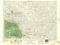
~ Rapid City SD topo map, 1:250000 scale, 1 X 2 Degree, Historical, 1957
Rapid City, South Dakota, USGS topographic map dated 1957.
Includes geographic coordinates (latitude and longitude). This topographic map is suitable for hiking, camping, and exploring, or framing it as a wall map.
Printed on-demand using high resolution imagery, on heavy weight and acid free paper, or alternatively on a variety of synthetic materials.
Topos available on paper, Waterproof, Poly, or Tyvek. Usually shipping rolled, unless combined with other folded maps in one order.
- Product Number: USGS-5609174
- Free digital map download (high-resolution, GeoPDF): Rapid City, South Dakota (file size: 19 MB)
- Map Size: please refer to the dimensions of the GeoPDF map above
- Weight (paper map): ca. 55 grams
- Map Type: POD USGS Topographic Map
- Map Series: HTMC
- Map Verison: Historical
- Cell ID: 68982
- Scan ID: 344864
- Woodland Tint: Yes
- Datum: Unstated
- Map Projection: Transverse Mercator
- Map published by United States Army Corps of Engineers
- Map published by United States Army
- Map Language: English
- Scanner Resolution: 600 dpi
- Map Cell Name: Rapid City
- Grid size: 1 X 2 Degree
- Date on map: 1957
- Map Scale: 1:250000
- Geographical region: South Dakota, United States
Neighboring Maps:
All neighboring USGS topo maps are available for sale online at a variety of scales.
Spatial coverage:
Topo map Rapid City, South Dakota, covers the geographical area associated the following places:
- Vale - Ridgeland Heights - Gayville - Woodville - Fairpoint - Clarkson Addition - Goiens (historical) - Sturgis - Terraville - Tomahawk - Roubaix - South Canyon Country Estates - Elizabethtown (historical) - Mystic - Pactola (historical) - Lancaster City (historical) - Carthage (historical) - Broadmoor Subdivision - Bear Butte - Hisega - Thunderbird Homes Addition - Myersville - Wildwood Addition - Central City - Cartesville (historical) - Buffalo Chip - Wasta - Fruitdale - Maitland - Pedro - Whitewood - Pluma - Ragged Top (historical) - Rapid City - Murphy - Trojan - Blackhawk - Colonial Pine Hills - Rochford - Arpan - Schaeferville - Belle Fourche - Flatiron I (historical) - Union Center - Twilight Hills Addition - Elmore - Plainview - Carbonate (historical) - Redfern - Sulphur - Green Valley - Snoma (historical) - Cheyenne Crossing - Dumont - Kirk - Summerset - Greenwood - Rapid Valley - Dalzell - Copper Camp (historical) - Johnson Siding - Blacktail - Newell - Jolly Dump - Clough - Marcus - Lead - Boneita Springs - Sioux Village - Saint Onge - Ashland Heights - Galena - J and E Trailer Court - Howes - Deadwood - Crook City - Englewood - Empire - Tilford - Terry - McGee - Volunteer - Spearfish - Bend - Dacy (historical) - Elm Springs - Hanna - Castle Rock - Carwye (historical) - Melcore Acres Subdivision - Gossage Memorial - Box Elder - Savoy - Creighton - Hereford - Victoria - Piedmont - Redowl - Avance (historical) - Fox Ridge
- Map Area ID: AREA4544-104-102
- Northwest corner Lat/Long code: USGSNW45-104
- Northeast corner Lat/Long code: USGSNE45-102
- Southwest corner Lat/Long code: USGSSW44-104
- Southeast corner Lat/Long code: USGSSE44-102
- Northern map edge Latitude: 45
- Southern map edge Latitude: 44
- Western map edge Longitude: -104
- Eastern map edge Longitude: -102


