
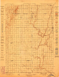
~ Ellendale ND topo map, 1:125000 scale, 30 X 30 Minute, Historical, 1899
Ellendale, North Dakota, USGS topographic map dated 1899.
Includes geographic coordinates (latitude and longitude). This topographic map is suitable for hiking, camping, and exploring, or framing it as a wall map.
Printed on-demand using high resolution imagery, on heavy weight and acid free paper, or alternatively on a variety of synthetic materials.
Topos available on paper, Waterproof, Poly, or Tyvek. Usually shipping rolled, unless combined with other folded maps in one order.
- Product Number: USGS-5609024
- Free digital map download (high-resolution, GeoPDF): Ellendale, North Dakota (file size: 7 MB)
- Map Size: please refer to the dimensions of the GeoPDF map above
- Weight (paper map): ca. 55 grams
- Map Type: POD USGS Topographic Map
- Map Series: HTMC
- Map Verison: Historical
- Cell ID: 65428
- Scan ID: 344781
- Survey Year: 1895
- Datum: Unstated
- Map Projection: Unstated
- Map published by United States Geological Survey
- Map Language: English
- Scanner Resolution: 600 dpi
- Map Cell Name: Ellendale
- Grid size: 30 X 30 Minute
- Date on map: 1899
- Map Scale: 1:125000
- Geographical region: North Dakota, United States
Neighboring Maps:
All neighboring USGS topo maps are available for sale online at a variety of scales.
Spatial coverage:
Topo map Ellendale, North Dakota, covers the geographical area associated the following places:
- Gederos Estates - Country Village Mobile Park - Spring Creek Colony - Wetonka - Bieglers First Addition - Richmond - Forbes - Frederick - Grassland Colony - Richmond Heights - Winship - Pleasant Vally Development - Richfield Heights - Long Lake Colony - Richmond Lake Heights Development - Leola - Fisher Estates - Deerfield Colony
- Map Area ID: AREA4645.5-99-98.5
- Northwest corner Lat/Long code: USGSNW46-99
- Northeast corner Lat/Long code: USGSNE46-98.5
- Southwest corner Lat/Long code: USGSSW45.5-99
- Southeast corner Lat/Long code: USGSSE45.5-98.5
- Northern map edge Latitude: 46
- Southern map edge Latitude: 45.5
- Western map edge Longitude: -99
- Eastern map edge Longitude: -98.5


