
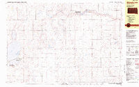
~ Wilmarth Lake SD topo map, 1:25000 scale, 7.5 X 15 Minute, Historical, 1982, updated 1983
Wilmarth Lake, South Dakota, USGS topographic map dated 1982.
Includes geographic coordinates (latitude and longitude). This topographic map is suitable for hiking, camping, and exploring, or framing it as a wall map.
Printed on-demand using high resolution imagery, on heavy weight and acid free paper, or alternatively on a variety of synthetic materials.
Topos available on paper, Waterproof, Poly, or Tyvek. Usually shipping rolled, unless combined with other folded maps in one order.
- Product Number: USGS-5608684
- Free digital map download (high-resolution, GeoPDF): Wilmarth Lake, South Dakota (file size: 20 MB)
- Map Size: please refer to the dimensions of the GeoPDF map above
- Weight (paper map): ca. 55 grams
- Map Type: POD USGS Topographic Map
- Map Series: HTMC
- Map Verison: Historical
- Cell ID: 75813
- Scan ID: 344592
- Imprint Year: 1983
- Woodland Tint: Yes
- Aerial Photo Year: 1978
- Edit Year: 1982
- Field Check Year: 1979
- Datum: NAD27
- Map Projection: Transverse Mercator
- Map published by United States Geological Survey
- Map Language: English
- Scanner Resolution: 600 dpi
- Map Cell Name: Wilmarth Lake
- Grid size: 7.5 X 15 Minute
- Date on map: 1982
- Map Scale: 1:25000
- Geographical region: South Dakota, United States
Neighboring Maps:
All neighboring USGS topo maps are available for sale online at a variety of scales.
Spatial coverage:
Topo map Wilmarth Lake, South Dakota, covers the geographical area associated the following places:
- Wilmarth Lake Game Production Area - Humphries Slough State Game Production Area - Phantom Lake - Dodds School - Wilkie Slough - Township of Firesteel - Turner School - National Waterfowl Production Area - Gunther School - Monitor School - Township of Lake - Township of Cooper - Union School - Archer Hill - White Lake - Wilmarth Dam - Wilkie Slough - Longfellow School - Cooper Townhall - Willow Bend School - Wilmarth Lake - Shottenkirk Lake - Maher School - Cruthoff School
- Map Area ID: AREA43.87543.75-98.75-98.5
- Northwest corner Lat/Long code: USGSNW43.875-98.75
- Northeast corner Lat/Long code: USGSNE43.875-98.5
- Southwest corner Lat/Long code: USGSSW43.75-98.75
- Southeast corner Lat/Long code: USGSSE43.75-98.5
- Northern map edge Latitude: 43.875
- Southern map edge Latitude: 43.75
- Western map edge Longitude: -98.75
- Eastern map edge Longitude: -98.5


