
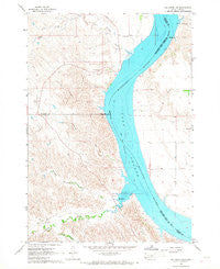
~ Joe Creek NW SD topo map, 1:24000 scale, 7.5 X 7.5 Minute, Historical, 1966, updated 1967
Joe Creek NW, South Dakota, USGS topographic map dated 1966.
Includes geographic coordinates (latitude and longitude). This topographic map is suitable for hiking, camping, and exploring, or framing it as a wall map.
Printed on-demand using high resolution imagery, on heavy weight and acid free paper, or alternatively on a variety of synthetic materials.
Topos available on paper, Waterproof, Poly, or Tyvek. Usually shipping rolled, unless combined with other folded maps in one order.
- Product Number: USGS-5606570
- Free digital map download (high-resolution, GeoPDF): Joe Creek NW, South Dakota (file size: 12 MB)
- Map Size: please refer to the dimensions of the GeoPDF map above
- Weight (paper map): ca. 55 grams
- Map Type: POD USGS Topographic Map
- Map Series: HTMC
- Map Verison: Historical
- Cell ID: 22638
- Scan ID: 343512
- Imprint Year: 1967
- Woodland Tint: Yes
- Aerial Photo Year: 1965
- Field Check Year: 1966
- Datum: NAD27
- Map Projection: Polyconic
- Map published by United States Geological Survey
- Map Language: English
- Scanner Resolution: 600 dpi
- Map Cell Name: Joe Creek NW
- Grid size: 7.5 X 7.5 Minute
- Date on map: 1966
- Map Scale: 1:24000
- Geographical region: South Dakota, United States
Neighboring Maps:
All neighboring USGS topo maps are available for sale online at a variety of scales.
Spatial coverage:
Topo map Joe Creek NW, South Dakota, covers the geographical area associated the following places:
- Fort au Cedras (historical) - Cedar Creek Island (historical) - Second Creek - Three Sisters Islands (historical) - First Creek - Holy Faith Cemetery - Cedar Creek - South Fork Cedar Creek - Loisels Post (historical) - Julius Creek - Cedar Creek Recreation Area - LaRoche School - Straight Creek - Dorion Island (historical) - Lake Sharpe - Clark Ranch - LaRoche Creek
- Map Area ID: AREA44.2544.125-100-99.875
- Northwest corner Lat/Long code: USGSNW44.25-100
- Northeast corner Lat/Long code: USGSNE44.25-99.875
- Southwest corner Lat/Long code: USGSSW44.125-100
- Southeast corner Lat/Long code: USGSSE44.125-99.875
- Northern map edge Latitude: 44.25
- Southern map edge Latitude: 44.125
- Western map edge Longitude: -100
- Eastern map edge Longitude: -99.875


