
~ J B Hill SD topo map, 1:24000 scale, 7.5 X 7.5 Minute, Historical, 1968, updated 1971
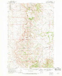
J B Hill, South Dakota, USGS topographic map dated 1968.
Includes geographic coordinates (latitude and longitude). This topographic map is suitable for hiking, camping, and exploring, or framing it as a wall map.
Printed on-demand using high resolution imagery, on heavy weight and acid free paper, or alternatively on a variety of synthetic materials.
Topos available on paper, Waterproof, Poly, or Tyvek. Usually shipping rolled, unless combined with other folded maps in one order.
- Product Number: USGS-5606518
- Free digital map download (high-resolution, GeoPDF): J B Hill, South Dakota (file size: 13 MB)
- Map Size: please refer to the dimensions of the GeoPDF map above
- Weight (paper map): ca. 55 grams
- Map Type: POD USGS Topographic Map
- Map Series: HTMC
- Map Verison: Historical
- Cell ID: 22218
- Scan ID: 343484
- Imprint Year: 1971
- Woodland Tint: Yes
- Aerial Photo Year: 1964
- Field Check Year: 1968
- Datum: NAD27
- Map Projection: Polyconic
- Map published by United States Geological Survey
- Map Language: English
- Scanner Resolution: 600 dpi
- Map Cell Name: J B Hill
- Grid size: 7.5 X 7.5 Minute
- Date on map: 1968
- Map Scale: 1:24000
- Geographical region: South Dakota, United States
Neighboring Maps:
All neighboring USGS topo maps are available for sale online at a variety of scales.
Spatial coverage:
Topo map J B Hill, South Dakota, covers the geographical area associated the following places:
- Thybo Ranch - Divide Spring - Road Draw Spring Number One - Meathook Spring - J B Spring - J B Pass - Township of Slim Buttes - M Hamilton Ranch - Deer Draw - Trail Spring - Tepee Canyon Spring - Blarney Castle Spring - Leatherburg Spring - Camp Spring - Jones Spring - Rock Ranch - Gray Spring - G Wammen Ranch - Jones Creek - Thybo Spring - Rabbit Creek Reservoir - Elliott Spring - Road Draw Spring Number Two - Slim Buttes - Andy Spring - Tepee Number One Spring - Beaver Spring - Road Draw - Ell Springs - Rock Ranch School - Blomberg Spring - Phillips Ranch - Rabbit Creek Dam - Colonel Spring - J B Hill - Wammen Spring - Carrot Spring - Slash Five Spring - Red Butte - H Hotchkiss Ranch - Square Top Butte - Rabbit Creek Spring - Jones Creek Spring - Red Tank Spring
- Map Area ID: AREA45.545.375-103.25-103.125
- Northwest corner Lat/Long code: USGSNW45.5-103.25
- Northeast corner Lat/Long code: USGSNE45.5-103.125
- Southwest corner Lat/Long code: USGSSW45.375-103.25
- Southeast corner Lat/Long code: USGSSE45.375-103.125
- Northern map edge Latitude: 45.5
- Southern map edge Latitude: 45.375
- Western map edge Longitude: -103.25
- Eastern map edge Longitude: -103.125


