
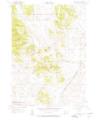
~ Butcher Hill SD topo map, 1:24000 scale, 7.5 X 7.5 Minute, Historical, 1957, updated 1963
Butcher Hill, South Dakota, USGS topographic map dated 1957.
Includes geographic coordinates (latitude and longitude). This topographic map is suitable for hiking, camping, and exploring, or framing it as a wall map.
Printed on-demand using high resolution imagery, on heavy weight and acid free paper, or alternatively on a variety of synthetic materials.
Topos available on paper, Waterproof, Poly, or Tyvek. Usually shipping rolled, unless combined with other folded maps in one order.
- Product Number: USGS-5605198
- Free digital map download (high-resolution, GeoPDF): Butcher Hill, South Dakota (file size: 11 MB)
- Map Size: please refer to the dimensions of the GeoPDF map above
- Weight (paper map): ca. 55 grams
- Map Type: POD USGS Topographic Map
- Map Series: HTMC
- Map Verison: Historical
- Cell ID: 6448
- Scan ID: 342855
- Imprint Year: 1963
- Woodland Tint: Yes
- Visual Version Number: 1
- Aerial Photo Year: 1954
- Field Check Year: 1957
- Datum: NAD27
- Map Projection: Polyconic
- Map published by United States Geological Survey
- Map Language: English
- Scanner Resolution: 600 dpi
- Map Cell Name: Butcher Hill
- Grid size: 7.5 X 7.5 Minute
- Date on map: 1957
- Map Scale: 1:24000
- Geographical region: South Dakota, United States
Neighboring Maps:
All neighboring USGS topo maps are available for sale online at a variety of scales.
Spatial coverage:
Topo map Butcher Hill, South Dakota, covers the geographical area associated the following places:
- Bud Hill - Custer State Park Airport - Racetrack Butte - Bobcat Canyon - East French Creek Primitive Campground - Dry Creek - Red Canyon - French Creek School - Cobb Ridge - South Fork Lame Johnny Creek - Gordon Canyon - Dry Creek School - Gregorson Number 1 Dam - Red Hill - Jolly Flats - Summit (historical) - French Creek Trailhead - Swint Creek - Dow Ridge - North Fork Lame Johnny Creek - Bald Hill - Butcher Hill - Melvin (historical) - Smith Number 1 Dam - Fairview School
- Map Area ID: AREA43.7543.625-103.375-103.25
- Northwest corner Lat/Long code: USGSNW43.75-103.375
- Northeast corner Lat/Long code: USGSNE43.75-103.25
- Southwest corner Lat/Long code: USGSSW43.625-103.375
- Southeast corner Lat/Long code: USGSSE43.625-103.25
- Northern map edge Latitude: 43.75
- Southern map edge Latitude: 43.625
- Western map edge Longitude: -103.375
- Eastern map edge Longitude: -103.25


