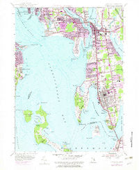
~ Bristol RI topo map, 1:24000 scale, 7.5 X 7.5 Minute, Historical, 1955, updated 1983
Bristol, Rhode Island, USGS topographic map dated 1955.
Includes geographic coordinates (latitude and longitude). This topographic map is suitable for hiking, camping, and exploring, or framing it as a wall map.
Printed on-demand using high resolution imagery, on heavy weight and acid free paper, or alternatively on a variety of synthetic materials.
Topos available on paper, Waterproof, Poly, or Tyvek. Usually shipping rolled, unless combined with other folded maps in one order.
- Product Number: USGS-5604116
- Free digital map download (high-resolution, GeoPDF): Bristol, Rhode Island (file size: 14 MB)
- Map Size: please refer to the dimensions of the GeoPDF map above
- Weight (paper map): ca. 55 grams
- Map Type: POD USGS Topographic Map
- Map Series: HTMC
- Map Verison: Historical
- Cell ID: 5499
- Scan ID: 353250
- Imprint Year: 1983
- Woodland Tint: Yes
- Photo Revision Year: 1975
- Aerial Photo Year: 1975
- Edit Year: 1955
- Survey Year: 1939
- Datum: NAD27
- Map Projection: Polyconic
- Map published by United States Geological Survey
- Map Language: English
- Scanner Resolution: 600 dpi
- Map Cell Name: Bristol
- Grid size: 7.5 X 7.5 Minute
- Date on map: 1955
- Map Scale: 1:24000
- Geographical region: Rhode Island, United States
Neighboring Maps:
All neighboring USGS topo maps are available for sale online at a variety of scales.
Spatial coverage:
Topo map Bristol, Rhode Island, covers the geographical area associated the following places:
- Highland Beach - West Barrington - Pocasset Heights - Bristol Ferry - Annawomscutt - Warren - Nayatt - Bristol Highlands - River View - Bristol Township - Sowams (historical) - Longmeadow - Barrington - Rocky Point - Maxfields Corner - Bay Spring - Laurel Park - Nag Creek - East Warren - Bristol - Beach Terrace
- Map Area ID: AREA41.7541.625-71.375-71.25
- Northwest corner Lat/Long code: USGSNW41.75-71.375
- Northeast corner Lat/Long code: USGSNE41.75-71.25
- Southwest corner Lat/Long code: USGSSW41.625-71.375
- Southeast corner Lat/Long code: USGSSE41.625-71.25
- Northern map edge Latitude: 41.75
- Southern map edge Latitude: 41.625
- Western map edge Longitude: -71.375
- Eastern map edge Longitude: -71.25