
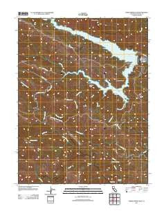
~ Warm Springs Dam CA topo map, 1:24000 scale, 7.5 X 7.5 Minute, Historical, 2012
Warm Springs Dam, California, USGS topographic map dated 2012.
Includes geographic coordinates (latitude and longitude). This topographic map is suitable for hiking, camping, and exploring, or framing it as a wall map.
Printed on-demand using high resolution imagery, on heavy weight and acid free paper, or alternatively on a variety of synthetic materials.
Topos available on paper, Waterproof, Poly, or Tyvek. Usually shipping rolled, unless combined with other folded maps in one order.
- Product Number: USGS-5603890
- Free digital map download (high-resolution, GeoPDF): Warm Springs Dam, California (file size: 22 MB)
- Map Size: please refer to the dimensions of the GeoPDF map above
- Weight (paper map): ca. 55 grams
- Map Type: POD USGS Topographic Map
- Map Series: US Topo
- Map Verison: Historical
- Cell ID: 47484
- Datum: North American Datum of 1983
- Map Projection: Transverse Mercator
- Map Cell Name: Warm Springs Dam
- Grid size: 7.5 X 7.5 Minute
- Date on map: 2012
- Map Scale: 1:24000
- Geographical region: California, United States
Neighboring Maps:
All neighboring USGS topo maps are available for sale online at a variety of scales.
Spatial coverage:
Topo map Warm Springs Dam, California, covers the geographical area associated the following places:
- Lake Sonoma - Sweetwater Creek - Little Warm Springs Creek - Black Sulfur Creek - Eagle Rock - Bummer Peak - Warm Springs Dam - Redwood Canyon - Redwood Log Creek - Strawberry Creek - Oak Knolls - Little Strawberry Creek - Wildcat Canyon - Woods Creek - Pechaco Creek - Reese Gap - Pritchett Peaks - Fall Creek - Willow Spring - Seven Oaks Creek - Little Rancheria Creek - Bearpen Creek - Skaggs Springs (historical) - Boyer Creek - Warm Springs Creek - Buzzard Rock - Wild Cattle Creek - Walbridge Ridge - Willow Springs Creek - Picnic Creek - Rancheria Creek - Bear Creek
- Map Area ID: AREA38.7538.625-123.125-123
- Northwest corner Lat/Long code: USGSNW38.75-123.125
- Northeast corner Lat/Long code: USGSNE38.75-123
- Southwest corner Lat/Long code: USGSSW38.625-123.125
- Southeast corner Lat/Long code: USGSSE38.625-123
- Northern map edge Latitude: 38.75
- Southern map edge Latitude: 38.625
- Western map edge Longitude: -123.125
- Eastern map edge Longitude: -123


