
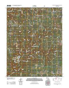
~ Dyestone Mountain MO topo map, 1:24000 scale, 7.5 X 7.5 Minute, Historical, 2012
Dyestone Mountain, Missouri, USGS topographic map dated 2012.
Includes geographic coordinates (latitude and longitude). This topographic map is suitable for hiking, camping, and exploring, or framing it as a wall map.
Printed on-demand using high resolution imagery, on heavy weight and acid free paper, or alternatively on a variety of synthetic materials.
Topos available on paper, Waterproof, Poly, or Tyvek. Usually shipping rolled, unless combined with other folded maps in one order.
- Product Number: USGS-5601816
- Free digital map download (high-resolution, GeoPDF): Dyestone Mountain, Missouri (file size: 29 MB)
- Map Size: please refer to the dimensions of the GeoPDF map above
- Weight (paper map): ca. 55 grams
- Map Type: POD USGS Topographic Map
- Map Series: US Topo
- Map Verison: Historical
- Cell ID: 13210
- Datum: North American Datum of 1983
- Map Projection: Transverse Mercator
- Map Cell Name: Dyestone Mountain
- Grid size: 7.5 X 7.5 Minute
- Date on map: 2012
- Map Scale: 1:24000
- Geographical region: Missouri, United States
Neighboring Maps:
All neighboring USGS topo maps are available for sale online at a variety of scales.
Spatial coverage:
Topo map Dyestone Mountain, Missouri, covers the geographical area associated the following places:
- Middle Indian Creek - North Fork Spring Creek - Crooked Creek - Noblett Creek - Twin Mountain - Noblett Trailhead - Noblett Lake Dam - Fields Store - Poison Hollow - Noblett Lake Campground - Group Camp Spring - Rockhouse Spring - Twin Bridges Volunteer Fire Department - Pine Grove School - Noblett Mill - Clearwater Reach Picnic Area - Noblett Lake - Fern Ridge School - Fern Glen School (historical) - Pine Grove Church - Ozarks - South Fork Spring Creek - Blue Rock Church - Sugar Hill Campground - Blue Buck Lookout Tower - Tater Hill - Fox Hollow - Pleasant Hill School (historical) - Sparkling Hollow - Dyestone Mountain - West Liberty School - Cord Hollow - Wolf Hollow - Noblett School (historical) - Flatrock School - Willow Springs Ranger District - Carmen Springs Wildlife Refuge Management Area - Brushy Creek - Carroll Cemetery - Blue Buck Knob - Carman Spring - C C C Camp (historical) - Spring Hollow - Galloway Spring - Dry Creek Church - Rockhouse Hollow - Hellroaring Spring - Little Indian Creek
- Map Area ID: AREA3736.875-92.125-92
- Northwest corner Lat/Long code: USGSNW37-92.125
- Northeast corner Lat/Long code: USGSNE37-92
- Southwest corner Lat/Long code: USGSSW36.875-92.125
- Southeast corner Lat/Long code: USGSSE36.875-92
- Northern map edge Latitude: 37
- Southern map edge Latitude: 36.875
- Western map edge Longitude: -92.125
- Eastern map edge Longitude: -92


