
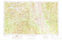
~ West Point MS topo map, 1:250000 scale, 1 X 2 Degree, Historical, 1963, updated 1963
West Point, Mississippi, USGS topographic map dated 1963.
Includes geographic coordinates (latitude and longitude). This topographic map is suitable for hiking, camping, and exploring, or framing it as a wall map.
Printed on-demand using high resolution imagery, on heavy weight and acid free paper, or alternatively on a variety of synthetic materials.
Topos available on paper, Waterproof, Poly, or Tyvek. Usually shipping rolled, unless combined with other folded maps in one order.
- Product Number: USGS-5599124
- Free digital map download (high-resolution, GeoPDF): West Point, Mississippi (file size: 20 MB)
- Map Size: please refer to the dimensions of the GeoPDF map above
- Weight (paper map): ca. 55 grams
- Map Type: POD USGS Topographic Map
- Map Series: HTMC
- Map Verison: Historical
- Cell ID: 69095
- Scan ID: 337283
- Imprint Year: 1963
- Woodland Tint: Yes
- Visual Version Number: 1
- Aerial Photo Year: 1952
- Field Check Year: 1953
- Datum: Unstated
- Map Projection: Transverse Mercator
- Map published by United States Army Corps of Engineers
- Map published by United States Army
- Map Language: English
- Scanner Resolution: 600 dpi
- Map Cell Name: West Point
- Grid size: 1 X 2 Degree
- Date on map: 1963
- Map Scale: 1:250000
- Geographical region: Mississippi, United States
Neighboring Maps:
All neighboring USGS topo maps are available for sale online at a variety of scales.
Spatial coverage:
Topo map West Point, Mississippi, covers the geographical area associated the following places:
- Southdale - Cady Hills - Macedonia - Hillbrook - Parkersburg - Thorn - Tranquil - Westwood - Foltz - Sherwood Forest - Beards Mill - Doyle Estates - Hopewell - Berea (historical) - Kingville - Crews - North Union (historical) - College View - Mantee - Point Harbor - Bigbee Valley - Magnolia Heights - Bear Creek (historical) - Weir - Nashdale - Flynn (historical) - Chestnut Subdivision - Palo Alto - Shady Grove - Christopher Hills - Wood Springs - Cedar Creek (historical) - West End - Ellis Subdivision - Rockport (historical) - Bedford - Boyette - Muldrow - Hillcrest - Sapps - Hohenlinden - Bowling Green - Center - Castalian Springs - Bellefontaine - Grenada - Roanoke Estates - Glenwild - Misterton - Pyland - Beasley - Fairground Subdivision - Propst Highlands - Murphree Subdivision - Pineview Estates - Lakeover Estates - Waddell - Bent Tree Plantation - Colonial Acres - Brooksville - Hickory Grove Estates - New Hope (historical) - Pilgrims Rest (historical) - Forest - Lake Monroe West Subdivision - Bywy - Billups - Burkettsville (historical) - Bent Oak - Ellison Ridge - Oakridge Estates - Carloss - Embry - Wise Gap - Cauhorn (historical) - Baker Subdivision - Pickensville - Plantation Homes - Calvary - Woodland Heights - Sweedenburg Estates - Lois Spring - Terrells (historical) - Dean Acres - Tucker Place - Sherwood Forest - Sonora - Waverly - Dixie (historical) - Fairport (historical) - Poplar Springs - Graysport Crossing - Loyd - Pleasant Ridge - Sunset - Grantsville (historical) - Kerr - Love Subdivision - Mayhew - Holladay
- Map Area ID: AREA3433-90-88
- Northwest corner Lat/Long code: USGSNW34-90
- Northeast corner Lat/Long code: USGSNE34-88
- Southwest corner Lat/Long code: USGSSW33-90
- Southeast corner Lat/Long code: USGSSE33-88
- Northern map edge Latitude: 34
- Southern map edge Latitude: 33
- Western map edge Longitude: -90
- Eastern map edge Longitude: -88


