
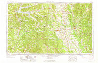
~ West Point MS topo map, 1:250000 scale, 1 X 2 Degree, Historical, 1963, updated 1963
West Point, Mississippi, USGS topographic map dated 1963.
Includes geographic coordinates (latitude and longitude). This topographic map is suitable for hiking, camping, and exploring, or framing it as a wall map.
Printed on-demand using high resolution imagery, on heavy weight and acid free paper, or alternatively on a variety of synthetic materials.
Topos available on paper, Waterproof, Poly, or Tyvek. Usually shipping rolled, unless combined with other folded maps in one order.
- Product Number: USGS-5599122
- Free digital map download (high-resolution, GeoPDF): West Point, Mississippi (file size: 18 MB)
- Map Size: please refer to the dimensions of the GeoPDF map above
- Weight (paper map): ca. 55 grams
- Map Type: POD USGS Topographic Map
- Map Series: HTMC
- Map Verison: Historical
- Cell ID: 69095
- Scan ID: 337282
- Imprint Year: 1963
- Woodland Tint: Yes
- Aerial Photo Year: 1952
- Field Check Year: 1953
- Datum: Unstated
- Map Projection: Transverse Mercator
- Map published by United States Army Corps of Engineers
- Map published by United States Army
- Map Language: English
- Scanner Resolution: 600 dpi
- Map Cell Name: West Point
- Grid size: 1 X 2 Degree
- Date on map: 1963
- Map Scale: 1:250000
- Geographical region: Mississippi, United States
Neighboring Maps:
All neighboring USGS topo maps are available for sale online at a variety of scales.
Spatial coverage:
Topo map West Point, Mississippi, covers the geographical area associated the following places:
- Hedgemoor - Lacy Subdivision - Timbercove - Bennett Subdivision - Athens - Templeton Meadows - Flint Hill - Dean Acres - Wesley (historical) - Vaiden - Coal Fire - Ridgeland - Osborn - Rye (historical) - Lobutcha (historical) - Mantee - Sherwood - Chalk Bluff (historical) - Beaverton - Cotton Gin Port (historical) - New Hamilton - Williamsville - Una - Randalls Bluff (historical) - Rocky Point - Walden (historical) - Mhoons Valley - New Hope (historical) - Sweedenburg Estates - Holly Hills - Kilmichael - Stephen - Huntsville - Chism Subdivision - X-Prairie - Louisville - Nashdale - Boyette - Hancock Circle - Aberdeen Junction - New Liberty - Hollis - McMullen - Tollison - Lake Monroe East Subdivision - Pikeville (historical) - Academy Park - Bethlehem - Cross Roads (historical) - Northgate - Beards Mill - Bruce Junction - New Hope Park - Unity (historical) - McCrary - McCarley - North Union (historical) - Emory - Pheba - New Hope - Lodi - Wood Manor - Greenacres - Memphis - Muldrow - Prairie Point - Gibson - Fox Run - Earlyville - Grenada Landing - Antioch (historical) - Pittsboro - Langley (historical) - Bruce - Clayton Village - Maben - Tanglewood - Green Acres - Kosciusko - Spring Hill - Bear Creek (historical) - Mashulaville - Harlan (historical) - Tucker Place - Coon Tail (historical) - Tillatoba - Partee - Westwood - Edsville - Susie - Highland Park - Glenwild - Ridge - Northwood Hills - Eupora - Hatley - Ashland (historical) - Pine Grove - Redding - Magnolia Heights
- Map Area ID: AREA3433-90-88
- Northwest corner Lat/Long code: USGSNW34-90
- Northeast corner Lat/Long code: USGSNE34-88
- Southwest corner Lat/Long code: USGSSW33-90
- Southeast corner Lat/Long code: USGSSE33-88
- Northern map edge Latitude: 34
- Southern map edge Latitude: 33
- Western map edge Longitude: -90
- Eastern map edge Longitude: -88


