
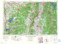
~ Tupelo MS topo map, 1:250000 scale, 1 X 2 Degree, Historical, 1984, updated 1984
Tupelo, Mississippi, USGS topographic map dated 1984.
Includes geographic coordinates (latitude and longitude). This topographic map is suitable for hiking, camping, and exploring, or framing it as a wall map.
Printed on-demand using high resolution imagery, on heavy weight and acid free paper, or alternatively on a variety of synthetic materials.
Topos available on paper, Waterproof, Poly, or Tyvek. Usually shipping rolled, unless combined with other folded maps in one order.
- Product Number: USGS-5599118
- Free digital map download (high-resolution, GeoPDF): Tupelo, Mississippi (file size: 20 MB)
- Map Size: please refer to the dimensions of the GeoPDF map above
- Weight (paper map): ca. 55 grams
- Map Type: POD USGS Topographic Map
- Map Series: HTMC
- Map Verison: Historical
- Cell ID: 69065
- Scan ID: 707644
- Imprint Year: 1984
- Woodland Tint: Yes
- Visual Version Number: 2
- Datum: Unstated
- Map Projection: Transverse Mercator
- Map published by United States Army Corps of Engineers
- Map Language: English
- Scanner Resolution: 508 dpi
- Map Cell Name: Tupelo
- Grid size: 1 X 2 Degree
- Date on map: 1984
- Map Scale: 1:250000
- Geographical region: Mississippi, United States
Neighboring Maps:
All neighboring USGS topo maps are available for sale online at a variety of scales.
Spatial coverage:
Topo map Tupelo, Mississippi, covers the geographical area associated the following places:
- Lafayette Springs - Paden - North Haven - Lime Kiln - Lakeview - Geeville - Shady Acres - Water Valley - Martintown - Terza - Potlockney - Fairfield - Park Monceau - Bright - Hightown - Lurline - Jago - Batesville - Byhalia - Red Banks - Plantersville - Pontotoc - Edgemont - West Fulton - Tupelo - Bacon Springs - Crumtown - Olive Branch - Pine Hill - Pisgah - Flatwood - Hamilton - Lumpkin Subdivision - Ashland - Cairo - Wallhill - Central Academy - Macedonia - Rolling Woods - Briarwood - Sharon Hills - Pleasant Hill - Crows Camp (historical) - College Hill Heights - Baldwyn - Ballardsville - University - Gershorm - New Hope - Riverside - Ingrams Mill - Glenville - Shiloh - Mount Olive (historical) - Chickasaw (historical) - Wheeler - Long Branch - Myrtle - Walnut - Independence - Troy - Post Estates - Maud - East Prentiss - Canaan - Boggan Grove - Oak Hill - Pine Grove - Fairhaven - McGhee - Free Springs - Malone - Wenasoga - Bynum - Rebecca Heights - Winborn - State Line (historical) - Jug Fork - Furrs - Woodland - Moores Mill - Carter Branch - Bounds Crossroads - Taska - Priceville - Doskie - Flinn - Chesterville - Eastwood Place - High Point - Old Myrtle - Haddock (historical) - Hudsonville - Enterprise - Nixon - New Bethel - Applewood - Banner - Birmingham - Mount Pleasant
- Map Area ID: AREA3534-90-88
- Northwest corner Lat/Long code: USGSNW35-90
- Northeast corner Lat/Long code: USGSNE35-88
- Southwest corner Lat/Long code: USGSSW34-90
- Southeast corner Lat/Long code: USGSSE34-88
- Northern map edge Latitude: 35
- Southern map edge Latitude: 34
- Western map edge Longitude: -90
- Eastern map edge Longitude: -88


